Regulation 18 Draft Local Plan
Chapter 10 – Protecting and Enhancing the Natural and Built Environments
(9) The Natural Environment
Landscape Character
10.1 The South Kesteven Landscape Character Assessment has been used by the Council to inform its Landscape Policy. This approach was adopted in the 2020 Local Plan. This piece of evidence has not been updated since then, however given it comments on landscape character which has not significantly altered this piece of evidence is not considered out of date.
10.2 The District can be divided into four National Landscape Areas and further subdivided into seven Landscape Areas, each with its own distinctive characteristics. The Kesteven Uplands, the largest and central part of the District, contains a high proportion of ancient woodlands, both semi-natural and replanted, and is abundant with species-rich calcareous grassland. The agricultural classification of the land is mainly Grade 3, with swathes of Grade 2 along the Lincoln Edge. The Fen area of South Kesteven is also Grade 2 high quality agricultural land. Within the Fens, ecological interest is concentrated around the drainage ditches which can support a range of wetland species.
10.3 Points of the Compass assessments are being undertaken for the towns and Larger Villages through the Local Plan's Sustainability Appraisal.
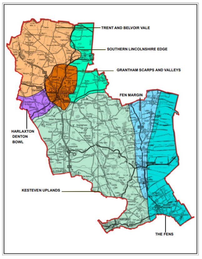

Figure 14: South Kesteven Landscape Character Area
Policy Type: To be reviewed once evidence is finalised
(12) EN1: Landscape Character
South Kesteven's Landscape Character Areas are identified on the map above (Figure 14). Development must be appropriate to the character and significant natural, historic and cultural attributes and features of the landscape within which it is situated, and contribute to its conservation and enhancement, and where relevant, its restoration.
In assessing the impact of proposed development on the Landscape, relevant Landscape Character Appraisals should be considered, including those within Neighbourhood Plans. Consideration should also be given to the Points of the Compass Assessments.
Summary of Proposed Changes
Policy EN1 has been amended for clarity. Points of the Compass assessments are being undertaken for the four towns and identified Larger Villages.
(8) Biodiversity and Geodiversity
10.4 The NPPF states "the planning system should contribute to and enhance the natural and local environment by:
- protecting and enhancing valued landscapes, geological conservation interests and soils;
- recognising the wider benefits of ecosystems;
- minimising impacts on biodiversity and providing net gains in biodiversity where possible, contributing to the Government's commitment to halt the overall decline in biodiversity, including by establishing coherent ecological networks that are more resilient to current and future pressures;
- preventing both new and existing development from contributing to or being put at unacceptable risk from, or being adversely affected by unacceptable levels of soil, air, water or noise pollution or land instability; and
- remediating and mitigating despoiled, degraded, derelict, contaminated and unstable land, where appropriate".
10.5 South Kesteven has a variety of nature reserves and protected sites as described below. These sites should be seen as part of an ecological network, managing, restoring and creating habitat in the right places helps rebuild a resilient network and enables species to thrive not just in one place but across wider landscapes. There are two Natura 2000 Special Area of Conservation (SAC) sites in the district: Baston Fen and Grimsthorpe Park. There are nearly 400 Tree Preservation Orders throughout the District and South Kesteven is also home to a nationally significant population of native White Clawed Crayfish.
10.6 Development will seek to provide net gain to the environment and biodiversity of the District, in particular Priority habitats and species. This will ensure that the wider benefits of the natural environment can be appreciated by all; this natural capital includes flood alleviation, pollination services, healthy soil and clean air.
10.7 The following nature sites are present within South Kesteven:
Table 9: Nature Sites
|
Designation |
Number of Sites |
|
Natura 2000 (Special Areas of Conservation) |
2 |
|
Sites of Special Scientific Interest (SSSI) |
27 |
|
National Nature Reserves (NNRs) |
None |
|
Local Wildlife Sites (LWS) |
229 |
|
Local Geological Sites (LGS) |
12 |
10.8 Sites that lie outside designated areas can also provide valuable spaces and corridors for protected habitats and species. Waterways, for example, can be valuable for biodiversity, providing green and blue corridors that link habitats and wildlife sites. Maintaining and enhancing a network of habitats, species and wildlife sites, and linkages between them, is important to achieving the vision and aims of the emerging Local Nature Recovery Strategy. Biodiversity Opportunity Mapping for South Kesteven District has been produced by the Greater Lincolnshire Nature Partnership which will aid ecological network enhancement.
Policy Type: Minor Changes to Policies
(10) EN2: Protecting Biodiversity and Geodiversity
The Council, working in partnership with all relevant stakeholders, will facilitate the conservation, enhancement and promotion of the District's biodiversity and geological interest of the natural environment. This includes seeking to enhance ecological networks and seeking to deliver a net gain on all proposals. Where development types are exempt from mandatory biodiversity net gain, it should be sought for its multiple benefits.
Proposals that are likely to have a significant impact on sites designated internationally, nationally or locally for their biodiversity and geodiversity importance, species populations and habitats identified in the emerging Local Nature Recovery Strategy Lincolnshire, Geodiversity Strategy and the Natural Environment and Rural Communities (NERC) Act 2006 will only be permitted in exceptional circumstances:
- In the case of internationally designated sites (alone or in combination), where there is no alternative solution and there are overriding reasons of public interest for the development.
- In the case of National Sites (alone or in combination) where the benefits of development in that location clearly outweigh both the impact on the site and any broader impacts on the wider network of National Sites.
- In the case of Local Sites (e.g. Local Wildlife Sites) or sites which meet the designation criteria for Local Sites, the reasons for development must clearly outweigh the long term need to protect the site.
In exceptional circumstances where detrimental impacts of development cannot be avoided (through locating an alternative site) the Council will require appropriate mitigation to be undertaken by the developers or as a final resort compensation. Where none of these can be achieved then planning permission will be refused. Where any mitigation and compensation measures are required, they should be in place before development activities start that may disturb protected or important species.
Planning permission will be refused for development resulting in the loss, deterioration or fragmentation of irreplaceable habitats, including ancient woodland and aged or veteran trees, unless the need for, and benefits of, the development in that location clearly outweigh the loss or harm.
Development proposals that are likely to result in a significant adverse effect, either alone or in combination, on any internationally designated site, must satisfy the requirements of the Habitats Regulations. Development requiring Appropriate Assessment will only be allowed where it can be determined, taking into account mitigation, that the proposal would not result in significant adverse effects on the site's integrity.
10.9 National planning policy states that development should deliver a net gain in biodiversity. The Environment Act sets out a mandatory requirement for development to deliver at least a 10% biodiversity net gain and approval of a biodiversity net gain plan. The Act includes provision for secondary legislation to set a date for the requirement to come into force.
10.10 Biodiversity net gain means leaving the natural environment in a measurably better state than before and is central to delivering nature's recovery and increasing stocks of natural capital. Net gain should deliver genuine additional improvements for biodiversity by creating or enhancing habitats in associating with development. As part of delivering net gains for nature, development proposals will be expected to protect, provide and extend green infrastructure in accordance with the Green Infrastructure policy.
10.11 Biodiversity Opportunity and Green Infrastructure Mapping has been prepared for South Kesteven District Council by the Greater Lincolnshire Nature Partnership. These maps identify known areas of high biodiversity value which make up the core of the District's wider ecological network through improved habitat management and habitat creation. To complement these maps, a set of principles has been prepared to guide development proposals that fall within or overlap the biodiversity opportunity area principles.
10.12 Guidance is currently being prepared by the Greater Lincolnshire BNG Task Group which will provide further guidance on providing biodiversity net gain through development proposals.
10.13 Major and large scale development schemes should deliver wider environmental net gain wherever possible, reflecting the opportunities identified in the South Kesteven Biodiversity Opportunity and GI Mapping; and the Local Nature Recovery Strategy (formerly Biodiversity Action Plans). Seeking to achieve overall improvements in, natural capital and ecosystem services and the benefits that they deliver.
10.14 The baseline data on habitats and species that underpin local biodiversity strategy, the local ecological network, biodiversity and green infrastructure opportunities will be kept up to date by the GLNP through the management of the Lincolnshire Environmental Record Centre.
Policy Type: New policy
(35) NEW POLICY 4: Biodiversity Opportunity and Delivering Measurable Net Gains
All development proposals should ensure opportunities are taken to retain, protect and enhance biodiversity and geodiversity features proportionate to their scale, through site layout, design of new buildings and proposals for existing buildings with consideration to the construction phase and ongoing site management.
Development proposals should create new habitats, and links between habitats, to maintain and enhance a network of wildlife sites and corridors, to minimise habitat fragmentation and provide opportunities for species to respond and adapt to climate change. This must be in line with South Kesteven Biodiversity Opportunity and Green Infrastructure Mapping evidence as set out in Appendix 1 and the Policies Maps, the biodiversity opportunity principles, and the Local Nature recovery Strategy (once completed).
Proposals for major development should seek to deliver wider environmental net gains where feasible.
All qualifying development proposals (as defined by the Environment Act 2021, Schedule 7A, Part 2, Paragraph 17) must deliver at least 10% measurable biodiversity net gain attributable to the development. The net gain for biodiversity should be calculated using Natural England's Biodiversity Metric.
Biodiversity net gain should be provided on-site where possible. Off-site measures will only be considered where it can be demonstrated that, after following the mitigation hierarchy, all reasonable opportunities to achieve measurable net gains on-site have been exhausted or where greater gains can be delivered off-site where the improvements can be demonstrated to be deliverable and are consistent with the Local Nature Recovery Strategy.
All development proposals must provide clear and robust evidence for biodiversity net gains and losses in the form of a biodiversity gain plan, which should be submitted with the planning application, setting out:
- The pre-development biodiversity value of the onsite habitat;
- Information about the steps to be taken to minimise the adverse effect of the development on the biodiversity of the onsite habitat and any other habitat;
- The post-development biodiversity value of the onsite habitat following implementation of the proposed ecological enhancements/interventions;
- The ongoing management strategy for any proposals; and
- Any registered off-site gain allocated to the development and the biodiversity value of that gain in relation to the development; and exceptionally any biodiversity credits purchased for the development through a recognised and deliverable offsetting scheme.
Demonstrating the value of the habitat (pre and post-development) with appropriate and robust evidence will be the responsibility of the applicant. Proposals which do not demonstrate that the post development biodiversity value will exceed the predevelopment value of the onsite habitat by a 10% net gain will be refused.
Ongoing management of any new or improved onsite and offsite habitats, together with monitoring and reporting, will need to be secured and funded for 30 years after completion of a development.
Summary of Proposed Changes
To accord with the requirement to deliver a minimum 10% biodiversity net gain on qualifying development sites, a new policy is proposed. The policy is based on emerging evidence Biodiversity Net Gain in Greater Lincolnshire – A Framework Approach Supplementary Planning Guidance which is a joint study led by the Greater Lincolnshire Partnership.
The policy also refers to Biodiversity Opportunity Mapping and Green Infrastructure Mapping, produced for the district by the Greater Lincolnshire Partnership in 2022. New appendices have been included which set out the principles for development within biodiversity opportunity areas and the Green Infrastructure Network . A Local Nature Recovery Strategy is also required and will be led by the County Council.
An accompanying Whole Plan Viability Assessment tests the viability of increasing the biodiversity requirement above 10%.
(5) Green Infrastructure
10.15 The concept of green infrastructure involves a connected approach to environmental management. It utilises a landscape scale approach and focuses on the relationships between habitats, greenspaces, such as green open spaces, blue spaces as networks and the wildlife/communities that they benefit, rather than on the needs of individual sites, species and neighbourhoods. Green infrastructure provides multiple benefits and vital functions for the economy, people, wildlife and communities including health, tourism, flood management, climate change mitigation and clean air. It will be highly valued and considered a priority within planning.
10.16 Green Infrastructure should provide for multi-functional uses for example wildlife, recreational and cultural experience, as well as delivering ecological benefits, flood protection and microclimate control. It includes habitats, rivers and their floodplains, greenspaces and civic areas and should operate at all spatial scales from urban centres through to open countryside. As such Policy OS1 should be read in conjunction with EN3.
10.17 Connectivity between different green infrastructure assets can help maximise the benefits that they generate. Well-connected green infrastructure assets create a network that allows and encourages movement by people and wildlife, helping to maximise the benefits and support adaptation and resilience to a changing climate.
10.18 The Council will work to ensure the promotion of green infrastructure, prioritising proposals that contribute to net gain and enhancement of green infrastructure.
10.19 Green Infrastructure and Biodiversity Opportunity Mapping has been prepared for South Kesteven District Council by the GLNP. These maps identify the known existing areas of high biodiversity value and areas of local biodiversity priority where it is considered most important and feasible to target habitat creation, extension, and restoration. To complement these maps, a set of principles has been prepared to guide development proposals that fall within or overlap the biodiversity opportunity areas. Development proposals are required to have regard to the above evidence and the biodiversity opportunity principles.
Policy Type: Significant Changes to Policy
(21) EN3: Green Infrastructure
The green infrastructure network in the District will be maintained and improvedby enhancing, creating and managing green space within and around settlements that are well connected to each other and the wider countryside.
Development proposals should ensure that existing and new green infrastructure is considered and integrated into the scheme design, taking opportunities to enrich biodiversity and habitats, enable greater connectivity and provide sustainable access for all. Proposals which may result in recreational and visitor pressure on designated biodiversity sites will be particularly expected to provide such green infrastructure.
Proposals that cause loss or harm to this network will not be permitted unless the need for and benefits of the development demonstrably outweigh any adverse impacts. In such cases development will only be permitted if suitable mitigation measures are provided to maintain the integrity of the green infrastructure network.
Development proposals must demonstrate how regard has been had to the Green Infrastructure Mapping prepared by the Greater Lincolnshire Nature Partnership (in conjunction with Appendix 2) and any relevant national evidence such as Natural England's Green Infrastructure Framework.
Summary of Proposed Changes
Policy EN3 has been strengthened and amended for clarity. Reference has also been made to the Green Infrastructure Mapping and associated appendix which has been undertaken in 2022 by the Greater Lincolnshire Nature Partnership for the district.
(5) Pollution Control
10.20 The NPPFsets out the need for local authorities to consider the impact of new development on noise, air and light pollution. The aim of the NPPF is to ensure that new developments do not harm existing residents, future residents or the natural environment. This includes minimising air, noise, light pollution, managing odour and maintaining or improving water quality to ensure that new developments are not harmful to other land uses, human health, tranquillity or the natural and built environment. The NPPF states that the local plan should seek to avoid and mitigate the impacts of pollution associated with development.
10.21 Potentially noisy developments will be expected to be accompanied by an appropriate noise assessment. Developers will be required to demonstrate the potential impact of proposals on the environment and on residential amenity and the ability to mitigate to an acceptable level.
10.22 Light pollution refers to the effect of excessive or intrusive lighting arising from poor or insensitive design. The Council will seek to reduce light pollution by encouraging the installation of appropriate lighting and only permitting lighting proposals which would not adversely affect amenity or public safety. Lights should be appropriately shielded, directed to the ground and sited to minimise any impact on adjoining areas, and of a height and illumination level of the minimum required to serve their purpose.
10.23 There is one Air Quality Management Area (AQMA) within the District. This is located in Grantham. This AQMA is within the urban area where air pollution results mainly from traffic. Air quality will be considered when assessing development proposals, particularly in or near the AQMA and where significant doubt arises as to the air quality impact then a cautious approach will be applied.
10.24 The Council is committed to improving air quality in the District and, where relevant, will follow the guidance in the East Midlands Air Quality Network Air Quality and Emissions Mitigation Guidance for Developers June 2017 (or other relevant guidance).
Policy Type: To be reviewed once evidence is finalised
(8) EN4: Pollution Control
Development should seek to minimise pollution and where possible contribute to the protection and improvement of the quality of air, land and water. In achieving this:
Development should be designed from the outset to improve air, land and water quality and promote environmental benefits.
Development that, on its own or cumulatively, would result in significant air, light, noise, land, water or other environmental pollution or harm to amenity, health well-being or safety will not be permitted. New development proposals should not have an adverse impact on existing operations.
Development will only be permitted if the potential adverse effects can be mitigated to an acceptable level by other environmental controls, or by measures included in the proposals.
Development that would lead to deterioration or may compromise the ability of a water body or underlying groundwater to meet good status standards in the Anglian River Basin Management Plan (required by the Water Framework Directive) will not be permitted.
Where development is situated on a site with known or high likelihood of contamination, remediation strategies to manage this contamination will be required.
Subject to the Policies in this Plan, planning permission will be granted for development on land affected by contamination where it can be established by the proposed developer that the site can be safely and viably developed with no significant impact on either future users or on ground and surface waters.
Summary of Proposed Changes
Policy EN4 is considered robust and no amendments are proposed at this draft stage.
(7) Reducing the Risk of Flooding
10.25 Paragraph 165 of the NPPF states that inappropriate development in areas at risk of flooding should be avoided by directing development away from areas of highest risk (whether existing or future). Where development is necessary in such areas, it should be made safe for its lifetime without increasing flood risk elsewhere.
10.26 The NPPF also states that Local Plans should be informed by a strategic flood risk assessment, and should manage flood risk from all sources. South Kesteven has commissioned a new SFRA in line with the NPPF requirements and in consultation with the Environment Agency and this will be the starting point for consideration of the sequential and the exception tests.
10.27 The NPPF states that all plans should apply a sequential, risk based approach to the location of development – taking into account all sources of flood risk and the current and future impacts of climate change – so as to avoid, where possible, flood risk to people and property. The NPPF sets out a number of criteria which must be met. The aim of the sequential test is to steer new development to areas with the lowest risk of flooding from any source.
10.28 If it is not possible for development to be located in areas with a lower risk of flooding (taking into account wider sustainable objectives), the exception test may have to be applied. The need for the exception test will depend on the potential vulnerability of the site and the development proposed. The NPPF includes a list of exception test criteria which must be passed.
10.29 The District contains some important Water Framework Directive (WFD) water bodies including the Upper Witham, River Welland and River Glen. The Upper Witham currently supports endangered native crayfish, brown trout and grayling. A range of pressures including poor habitat, diffuse and point source pollution, invasive species and low flows are impacting these water bodies and preventing the target of good status from being achieved.
10.30 There is a requirement for the WFD status of surface and ground water bodies across the district to be improved. Therefore, the Council will seek to deliver improvements to the water environment through development, which will not only help to improve WFD status but can deliver multiple benefits. The proposals to create a green corridor along the Witham in Grantham shows the potential for what can be achieved when considering growth alongside environmental enhancement opportunities.
10.31 The WFD requires Member States to achieve 'good ecological status' in all surface freshwater bodies between 2015 and 2027 and to ensure that in future there is no 'deterioration' of the ecological potential of the water environment. Different water bodies are categorised based on four elements - biology, chemical water quality, physical structure and water quality – which together determine the overall ecological potential of the surface water environment. The Anglian River Basin Management Plan details what actions need to be taken in order for the WFD requirements to be met in the area. Development that could potentially lead to river status deterioration or compromise the achievement of good ecological status as set out in the Anglian River Basin Management Plan should be accompanied by a suitable assessment and proposals for mitigation.
10.32 There is a presumption against the use of non-mains foul drainage, except where it is proven that it is not reasonable to use mains drainage, taking into account cost, practicality and sustainability.
10.33 Brownfield land may be subject to contamination from previous uses, which can pose risk to surface water, human health and the wider environment. South Kesteven's geology includes large areas dominated by Lincolnshire Limestone which is classified as a Principal Aquifer. These aquifers exhibit high permeability and provide a high level of water storage. They support water supply and river base flow on a strategic scale. Other substantial areas of South Kesteven are located over sand and gravel deposits which are classified as Secondary Aquifers. These aquifers support water supplies at a local scale and in some cases form an important source of base flow to rivers. Principal and Secondary Aquifers are vulnerable to contaminants.
10.34 The Environment Agency is the statutory body responsible for the management of groundwater resources. As such proposed development on Brownfield sites should be considered in the context of its prepared guidance on groundwater protection 'The Environment Agency's approach to groundwater protection' which sets out its approach to the management and protection of groundwater. The guidance is available on the Gov.UK website.
10.35 Contamination can also occur in other locations, including in the countryside (e.g. by inappropriate spreading of materials such as sludges, or as a result of contamination being moved from its original source).
10.36 In addition, some areas may be affected by the natural or background occurrence of potentially hazardous substances, such as radon, methane or elevated concentrations of metallic elements.
10.37 In enabling redevelopment of brownfield sites remediation may be necessary. The level of remediation required will be dependent on the proposed end use of the land.
10.38 Where development is proposed on a site which is known or has the potential to be affected by contamination, a preliminary risk assessment should be undertaken by the developer and submitted to the local planning authority as the first stage in assessing the risk. Preliminary risk assessments and subsequent investigations should be carried out in accordance with Environment Agency procedures.
10.39 Unless this initial assessment clearly demonstrates that the risk from contamination can be satisfactorily reduced to an acceptable level, further site investigations and risk assessment will be needed before the application can be determined.
10.40 Remediation strategies should be proportionate to the proposed end use and should seek to ensure that there is no additional risk arising from the development. Remediation strategies are dependent on desktop/research based survey and potentially testing/site investigation and these will advise the necessary level of remediation. Prior to submitting SuDS proposals, developers should ensure that land is suitable for soakaways, and that the soakaways would provide effective drainage and protect vulnerable groundwater from contamination.
10.41 Where pollution issues are likely to arise, intending developers should hold pre-application discussions with the local planning authority, the relevant pollution control authority and stakeholders with a legitimate interest.
10.42 In cases where planning permission is granted for development of a site on which the presence of contamination is known or suspected, the responsibility for safe development for the site rests with the developer and landowner.
Policy Type: To be reviewed once evidence is finalised
(16) EN5: Water Environment and Flood Risk Management
Development should be located in the lowest areas of flood risk, in accordance with the South Kesteven Strategic Flood Risk Assessment (SFRA) and Environment Agency flood risk maps. Where new development is proposed within high risk flood areas a sequential test must be carried out and submitted as part of the application. The scope of any sequential assessment must be agreed in advance with the Local Planning Authority. Where the requirements of the sequential test are met, the exception test will be applied, where necessary.
A Flood Risk Assessment (FRA) will be required for all development in Flood Zones 2 and 3 and for sites greater than 1 hectare in Flood Zone 1, and where a development site is located in an area known to have experienced flood problems from any flood source, including critical drainage.
All development must avoid increasing flood risk elsewhere. Runoff from the site post development must not exceed pre-development rates for all storm events up to and including the 1% Annual Exceedance Probability (AEP)* storm event with an allowance for climate change. The appropriate climate change allowances should be defined using relevant Environment Agency guidance.
Surface water should be managed effectively on site through the use of Sustainable Drainage Systems (SuDs) unless it is demonstrated to be technically unfeasible. All planning applications should be accompanied by a statement of how surface water is to be managed and in particular where it is to be discharged. Surface water connections to the public sewage network should only be made in exceptional circumstances. On-site attenuation and infiltration will be required as part of any new development wherever possible. Opportunities must be sought to achieve multiple benefits, for example through green infrastructure provision and biodiversity enhancements in addition to their drainage function. The long-term maintenance of structures such as swales and balancing ponds must be agreed in principle prior to permission being granted.
Development proposals should demonstrate that water is available to serve the development and adequate foul water treatment and disposal already exists or can be provided in time to serve the development. Foul and surface water flows should be separated where possible.
Suitable access should be maintained for water resource and drainage infrastructure.
Where development takes place in Flood Zones 2 and 3, opportunities should be sought to:
- Reduce flooding by considering the layout and form of the development and the appropriate application of sustainable drainage techniques;
- Relocate existing development to land in zones with a lower probability of flooding; and
- Create space for flooding to occur by restoring functional floodplains and flood flow pathways and by identifying, allocating and safeguarding open space for storage.
*1% Annual Exceedance Probability (AEP): 1 in 100 chance of flooding in any one year
Summary of Proposed Changes
Policy EN5 has been amended for clarity.
The Council is preparing a revised Flood Risk Assessment and Water Cycle study and policy EN5 will be reviewed again in line with the emerging evidence.
(5) The Historic Environment
10.43 The National Planning Policy Framework (NPPF) states that the Local Plan should set a positive strategy for the conservation and enjoyment of the Historic Environment. The Local Plan should take account of:
- the desirability of sustaining and enhancing the significance of heritage assets and putting them to viable uses consistent with their conservation;
- the wider social, cultural, economic and environmental benefits that conservation of the historic environment can bring;
- the desirability of new development making a positive contribution to local character and distinctiveness; and
- opportunities to draw on the contribution made by the historic environment to the character of a place.
10.44 The Council has adopted a number of policies relating to the historic environment in the past and to date a number of conservation area appraisals have been produced and 48 conservation areas declared. The District has the following designated heritage assets:
|
Conservation Areas |
48 |
|
Listed Buildings |
2150 |
|
Scheduled Monuments |
92 |
|
Historic Parks and Gardens |
10 |
Policy Type: Significant Changes to Policy
(17) EN6: The Historic Environment
The Council will seek to protect and enhance heritage assets and their settings in keeping with the policies in the National Planning Policy Framework.
Development that is likely to cause harm to the significance of a heritage asset or its setting will only be granted permission where the public benefits of the proposal outweigh the potential harm. Proposals which would conserve or enhance the significance of the asset shall be considered favourably. Substantial harm or total loss will be resisted.
Conservation Areas
Proposals will be expected to take Conservation Area Appraisals into account, where these have been adopted by the Council.
For proposed development within, affecting the setting of, or affecting the views into or out of a Conservation Area, the Council will require the developer to conserve, or where possible enhance, features that contribute positively to the area's special character, appearance and setting. Development proposals should aim to:
- assess, and mitigate against, any negative impact the proposal might have on the wider streetscape and surrounding heritage assets;
- retain the existing buildings/groups of buildings, street patterns, and building lines that contribute to the character and appearance of the area;
- retain individual features of interest such as doorways, windows, shopfronts, garden walls, railings, cobbled or flagged forecourts, sandstone kerbs, trees and hedges. Where this is not possible or practical any replacement should match the original.
- retain the local distinctiveness as characterised by the height, massing, scale, form, and materials of the existing built environment;
- Ensure the preservation of trees within the Conservation Area, and if suggesting potential removal of trees, demonstrate effective mitigation measures.
The Council would support, where relevant and practical, the removal of features which have a negative impact on the character and appearance of the Conservation Area.
Designated Heritage Assets/Listed Buildings
Proposals for developments that are likely to cause harm to the significance of a designated heritage asset such as a Conservation Area, Listed Building, Designated Park or Garden or its setting will only be granted permission where the public benefits of the proposal outweigh the potential harm.
A Heritage Impact Assessment should be provided which considers:
- the overall significance of the heritage asset, including its architectural, archaeological and historic interest, and its contribution to the local character of the surrounding area;
- the setting of the asset and its contribution to the surrounding area;
- the extent of the public benefits created by the proposed works; and
- the present or future economic viability or function of the heritage asset.
The proposals should preserve physical features of significance of the building (both internally and externally), including the preservation of any windows and doorways. If significant interventions are proposed to a heritage asset, a full record should be produced prior to any works.
Scheduled Monuments
Development will not be permitted where it would cause substantial harm to the significance of a Scheduled Monument, or their setting. Direct impact upon Scheduled Monuments should be avoided given their national significance, to preserve the assets in situ. Proposals causing indirect impact upon the setting of a Scheduled Monument should consider appropriate design and mitigation to minimise such impacts.
Proposals should be accompanied by a Heritage Impact Assessment, identifying the significance of the asset and how it will be affected by the proposed development. The level of information required will be proportionate to the scale of impact of the proposal, but may require, where necessary, an in-depth archaeological desk-based assessment and further field evaluation.
Non-Designated Heritage Assets and Archaeological Assets
Where development affecting archaeological sites is acceptable in principle, the Council will seek to ensure mitigation of impact through preservation of the remains in situ as a preferred solution.
For areas of archaeological interest, or with known archaeological features, proposals should be accompanied by an appropriate and proportionate assessment to understand the potential for and significance of remains, and the impact of development upon them, in the form of a Desk-Based Assessment or Impact Assessment.
If the initial assessment does not provide sufficient information, developers will be required to provide further information, such as geophysical surveys or field evaluation in advance of determination of the application.
Where possible, mitigation strategies should prioritise the in-situ preservation of archaeological remains. Where this is not possible or feasible, a Preservation by Record should be undertaken, according to an agreed Written Scheme of Investigation, submitted by the developer and approved by the council. All archaeological interventions undertaken during the planning process should be appropriately archived using a method agreed by the council.
When in situ preservation is not practical, the developer will be required to make adequate provision for a full excavation and recording before or during development.
Summary of Proposed Changes
Policy EN6 has been separated out into sections on conservation areas, Designated Heritage Assets/Listed Buildings Scheduled Monuments Non-Designated Heritage Assets and Archaeological Assets. This is to allow each of these heritage assets to be assessed individually, and allows the council to provide a more detailed advice for each asset. The more detailed Policy now provides information on what needs to be considered as part of the planning process for developments.
(3) The Grantham Canal
10.45 The 33-mile long Grantham Canal was built in the 18th Century as a reliable transport connection between Grantham and Nottingham through the Vale of Belvoir. Whilst the canal officially closed in 1936 it was retained for land drainage and much of the canal remained in water due to agreements for irrigating agriculture. Strategic road infrastructure and associated bridges now constrain the canal's navigation but the canal and towpaths are still accessible to walkers and cyclists. The Grantham canal is recognised for its nationally and regionally significant landscape, wildlife and heritage features.
10.46 To support the emerging strategy for the Grantham Canal, commissioned by the Canal and River Trust on behalf of the Grantham Canal Partnership, Policy EN6 of the Local Plan requires future development proposals to both protect and enhance the stretch of the Grantham canal that runs through the District. The Local Plan seeks to safeguard the canal so that its long term potential as an asset to support growth of the local economy and boost tourism can be fully realised.
Policy Type: To be reviewed once evidence is finalised
(7) EN7: Protecting and Enhancing Grantham Canal
The alignment of the Grantham Canal, as shown indicatively on the Policies Map, shall be safeguarded with a view to its long term re-establishment as a navigable waterway, by:
- ensuring that development protects the integrity of the canal alignment and its associated structures;
- ensuring that where the canal is affected by development, the alignment is protected or an alternative alignment is provided; and
- ensuring associated infrastructure of development does not prejudice the delivery of the canal.
Proposals will be permitted that are designed to develop the canal's recreational, nature conservation, heritage, and tourism potential.
Proposals shall only be permitted if it can be demonstrated that there is no unacceptable risk to ecology, flood risk, water resources and water quality.