Regulation 18 Draft Local Plan
(4) Chapter 12 – South Kesteven's Communities
12.1 In addition to Policy H1, housing allocations for the Plan Period are set out in the following sections in order that these can be seen within the context of our communities. Allocations have been made for each of the main towns with a focus on Grantham, as well as the majority of the larger villages. In order to demonstrate that the allocated sites are capable of meeting the housing requirement over the plan period, the following assumptions have been made regarding density:
12.2 Planning Practice Guidance states that housing potential should be guided by local conditions, including housing densities and the sites' potential using an average development density of 30 dwellings to the hectare. However, this density has been adjusted to take account of any individual site characteristics and physical constraints.
12.3 When developing sites, it is usual for a proportion of the site to be given over to access roads, public open space and other ancillary uses. Site areas are recorded "gross" but to reflect the realities of development, sites have been "netted" down in order to calculate density. The larger the site, the larger the area normally given over to non-developed uses. We have therefore used the following assumptions:
- up to 1ha then 95% developable area
- between 1ha and 4ha 80% is developable area
- over 4ha then 60% developable area.
12.4 The dwelling potential of sites included in the Local Plan is indicative only; the true potential of any site will be assessed by more detailed study, having regard to many factors which are outside the scope of the Local Plan, and which need to be considered as part of the planning application process.
12.5 Some sites have been considered to have a lower density, due to their sensitive location and this is reflected in the indicative density. Again, this is not a rigid number, but it would not normally be considered that a much higher density would be appropriate in this location.
(2) South Kesteven's Four Market Towns
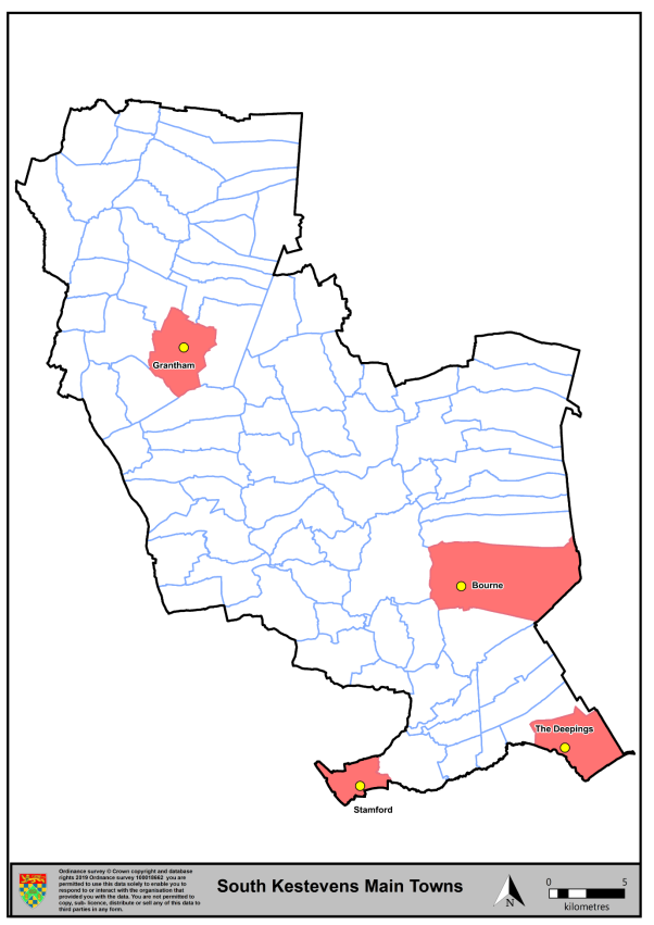
Figure 16: The Four Main Towns of South Kesteven, Map and Infographic Data.
(4) Grantham
12.6 Grantham is located around 26 miles south of Lincoln and 24 miles east of Nottingham. It is the largest settlement within the District of South Kesteven, and the second largest settlement in Lincolnshire. The town has historically been of strategic importance due to its location on the River Witham, along with the Great North Road and with the East coast Main Line running through it. It has good strategic connections to London, Peterborough, Newark, Lincoln and Nottingham. Being the largest town in the District, Grantham was previously awarded Growth Point status in 2006, in order to support an ambitious growth agenda, aimed at strengthening and enhancing Grantham's position as a major economic centre within Lincolnshire. Whilst formally Grantham's Growth Point status has concluded, the projects associated with it are still active and work continues to ensure that Grantham fulfils its ambition to be a leading sub-regional centre offering high quality retail, leisure, residential and employment opportunities to the whole of its hinterland.
12.7 Grantham has an historic and diverse town centre, with the full range of facilities, which you would expect to find in an urban centre of over 41,000 people. Many of the major national retailers have stores in the town, and there are branches of the leading supermarkets and the major banks.
(2) Grantham Historic Environment
12.8 In the centre of Grantham is the Grade 1 listed St. Wulfram's parish church. The church and its immediate setting are important features of the Conservation Area and the wider area, they are also the most historic parts, and as such are highly significant in their historic importance, and therefore very sensitive to any change or alteration. The views to the spire of St Wulfram's Church are one of the defining characteristics of Grantham. St Wulfram's spire is prominent in both short and long views and the protection of these should be weighed up in the consideration of any development proposals both within and outside the town.
12.9 The Grade 1 listed Belton House and its Grade 1 registered historic park and garden are internationally significant heritage assets located in close proximity to the northern edge of the existing built up area of Grantham.
12.10 In recognition of its importance the Council and the National Trust commissioned the Belton House and Park Setting study to define the extent of the setting of these heritage assets and to inform policy formulation and decision-making for development proposals within the defined area.
12.11 Protecting and enhancing the setting, to the extent defined in the adopted Belton House and Park Setting Study, is important in maintaining its significance as a heritage asset. In accordance with Policy GR1 development proposals will need to demonstrate what, if any, impact there will be on the setting of Belton House and Park through the preparation of a Heritage Impact Statement.
Policy Type: To be reviewed once evidence is finalised
(7) GR1: Protecting and Enhancing the Setting of Belton House and Park
Belton House and its Historic Park and Garden are nationally and internationally significant heritage assets located in close proximity to the northern edge of the existing built-up area of Grantham. Protecting and enhancing their setting, using the Belton House and Park Setting study to inform the assessment of the impacts, is important to maintaining their significance as heritage assets. Proposals will need to demonstrate what, if any, impact there will be on the setting of Belton House and Park through the preparation of a Heritage Impact Statement, and how through their location, scale, design, landscaping and materials they have taken account of the setting of Belton, and that any adverse impacts have been removed and/or mitigated.
Summary of Proposed Changes
Policy GR1 is considered robust and no amendments are proposed at this draft stage.
(5) Supporting Grantham's Economy
12.12 The town's economy has traditionally been reliant on industries like manufacturing, engineering, construction and wholesale retail trade. However, the distribution and visitor/tourism service sectors have taken an increased role in employment provision over recent years with much of the town's employment now focused within the service sector.
12.13 Employment in the town is mainly focused in the town centre; but also, at other locations such as Alma Park industrial Estate and Spitalgate Level industrial area, near to the A1. Unemployment in the town is at 4.2% which is higher than the District average of 2.9%.
12.14 The Local Plan seeks to strengthen the District's economy and through the identification of a series of employment sites which seek to further enhance Grantham's local economy such that Grantham can sustain and develop its role as an effective sub-regional centre.
12.15 The proposed Southern Gateway strategic employment location in Grantham (E1: Grantham Southern Gateway Strategy Employment Opportunity) recognises the benefit the delivery of employment generating uses on this site will bring to the local economy. This location will have excellent connectivity to the A1 and national road network by means of a new junction with the new Grantham Southern Relief Road.
12.16 In recognition of the new A1 junction being delivered in conjunction with developments to Grantham South, further land adjoining the strategic employment site is also identified for employment allocations. Delivery of employment generating uses on these sites will further support Grantham's economy, as well as the wider District's economy.
(2) Sustainable Transport in Grantham
12.17 The growth of the town requires an efficient transport network which enables services and facilities to be accessible to all, whilst also helping to reduce congestion and minimising the environmental impact of transport, particularly through the town centre.
12.18 Grantham lies adjacent to the A1 and it is currently bisected by the A52. As trunk roads, the A1 and A52 (west) are the responsibility of Highways England rather than Lincolnshire County Council. Development proposals which may have an effect on the trunk road network, including the capacity of junctions onto and off the trunk road network will be considered by Highways England as well as Lincolnshire County Council. Development proposals may therefore, require a strategic highway solution involving both LCC and Highways England.
12.19 In 2022, LCC published the Grantham Transport Strategy. The aim of the study is to ensure that Grantham has the infrastructure it needs to meet travel demands over the coming decades. The Strategy includes the following four priorities:
- Influencing travel behaviours: helping to provide greater choice in meeting daily activities from home without the need to travel (i.e. hybrid working). When people do need to make journeys, influencing where these are from and to, so that distance travelled is reduced;
- Prioritising active modes: making cycling and walking the preferred options for shorter journeys by considerably improving infrastructure;
- Promote shared and public transport: encouraging existing and new forms of public and shared transport for longer distance journeys by providing priority measures and increasing frequency and level of service; and
- Mitigate residual impacts of traffic: where there is no realistic alternative, longer journeys will still need to be made by car. Where this is the case, the impact of the resulting traffic and pollution will be mitigated.
12.20 Lincolnshire County Council has plans for significant highway infrastructure which will be delivered in Grantham. The construction of the Southern Relief Road (GSRR) is estimated to be fully built in 2025. This infrastructure will support and enable the growth of the town by opening up access to key development sites and by providing mitigation to traffic growth associated with all planned development. It is important to recognise the benefit and mitigation that this infrastructure will provide to all development sites within the Grantham Transport strategy area. Development proposals will therefore be expected to make appropriate direct provision or a financial contribution to the delivery of this enhanced infrastructure.
Policy Type: To be reviewed once evidence is finalised
(4) GR2: Sustainable Transport in Grantham
All major development proposals within the Grantham Transport Strategy area, and additionally proposals for development on site reference GR.SE1 under Policy E1, site reference GR3-H1 under Policy GR3 and any other land in proximity to the Grantham Southern Relief Road, should make an appropriate contribution to necessary transport improvements and the delivery of the objectives of the Grantham Transport Strategy, either directly where appropriate (such as the provision of infrastructure or through the contribution of land to directly enable a scheme to occur) or indirectly (such as through appropriate developer contributions to an identified scheme).
Summary of Proposed Changes
Policy GR2 is considered robust and no amendments are proposed at this draft stage.
(9) GR3: Grantham Allocations
12.21 Over half of the current existing total housing land supply is located within Grantham. This also takes into account the retained allocations (Spitalgate Health Garden Village, Rectory Farm (Phase 2 and Phase 3), and Prince William of Gloucestershire Barracks).
12.22 The proposed site allocations (Land at Sheepwash Lane, Grantham Train Station, Land at Belton Lane, and The Grantham High School Playing Fields) and retained allocations are expected to deliver 5,693 new homes across the plan period up to 2041. This approach ensures development is located in the most sustainable locations and ensures Grantham meets its growth needs and fulfils its role a sub-regional centre.
Policy Type: Minor Changes to Policy
(17) SKPR-278 (GR3-H1): Spitalgate Heath - Garden Village (Mixed Use Allocation)
Indicative Unit Numbers: 3700 (1,350 anticipated to be constructed by 2041)
Approximate Density: 30 Dwellings per hectare.
Planning permission will be granted for the creation of a Garden Village at Spitalgate Heath. The development must ensure that the following principles are met:
- To ensure the comprehensive development of the entire allocation, incremental full applications will not be acceptable. An outline or hybrid application will be required for the entire site. This must be accompanied by a detailed masterplan.
- The site must be planned and developed on the basis of current Garden Village principles and national best practice.
- The overall design of the Garden Village must provide a model for sustainable living with exemplary standard of design, construction and community facilities. The design and layout must foster and support a sense of community. To ensure the development achieves good, high quality design, a design code will be prepared for the site.
- The development must include a new employment generating area of approximately 110,000 m2 including E(g), B2 and B8 uses.
- The development must make provision for safe and convenient highways, footway and cycleway connections through the site connecting it to local schools, community facilities, linking it to Grantham, the Prince William of Gloucester Barracks allocated site and the wider countryside.
- The layout of the development must provide appropriate transport infrastructure measures to encourage walking, cycling and use of public transport in order to maximise opportunities for sustainable modes of transport and encourage active travel. This must include a walking and cycling route to Grantham along the River Witham corridor.
- The development must incorporate Sustainable Drainage Systems, except where it can be demonstrated that is not practical or possible to do so.
- The masterplanning and development of the site must have careful regard to landscape and topography.
- The potential for the development to impact on the townscape and heritage assets including views out of the site must be considered and reflected in the masterplanning of this site.
- The development must provide net gains in biodiversity on site and contribute to wider ecological networks where possible. This site is within or includes an area of Biodiversity Opportunity. Proposals on this site should incorporate the relevant principles for development within Biodiversity Opportunity Areas set out in New Policy 4: Biodiversity Opportunity and Delivering Measurable Net Gains.
- This site is within or includes a Green Infrastructure Area. Proposals on this site should incorporate the relevant principles for development within Green Infrastructure Areas set out in Policy EN3 Green Infrastructure.
- The development must seek to improve biodiversity and avoid, or minimise, impacts on Woodnook Valley SSSI.
- Additional treatment capacity is required at waste water treatment works and new discharge permits are required for water quality targets. This should be incorporated early on in the development of scheme specifics, as part of a scheme wide delivery strategy which demonstrates that capacity is available or could be made available to serve the development subject to phasing.
- The development must include on-site renewable energy provision and demonstrate how it will be resilient to future climate change.
- The development must provide a village hub with community facilities, including a community centre and shops to serve the day and day needs of future residents and create a community destination to support a sense of community.
- The development must provide an appropriate mix of housing types, affordability and tenures for all stage of life to meet housing needs.
- The development must provide primary and secondary schools on site, as required.
- The development must provide blue green infrastructure throughout the site including multifunctional green spaces, high quality open space, a Riverside Park, accessible opportunities for recreation through the provision of open space and private gardens, green access routes and allotments.
- The development must make provision for the long term stewardship of the site, demonstrating how this will be secured to support the new community and to ensure the creation of a flourishing and vibrant place where people want to live and work in the future.
- The development must contribute towards the delivery of the Grantham Southern Relief Road which facilitates this development.
- This site is situated within a Minerals Safeguarding Area. A Minerals Assessment will be required to accompany any planning application for the subject.
Summary of Proposed Changes
Policy GR3-H1 (SKPR-278) has been amended to reflect Garden Village status of the site, and the need to provide high quality development and to provide greater clarity for the key issues to be addressed.
Policy Type: Minor Changes to Policy
(11) SKPR-279 (GR3-H2): Rectory Farm (Phase 2)
Indicative Unit Numbers: 1150
Approximate Density: 30 Dwellings per hectare
Development of the Rectory Farm (Phase 2)must be planned for in a comprehensive manner such that each of the three phases (and corresponding landowners/developers/site promoter(s)) work together to provide a single urban extension.
The Council will work with the site promoter(s) / landowners / developers to ensure that a planning application / master planning strategy is developed that enables planning applications for the site to be progressed without compromising the delivery of the whole site comprehensively. Any application must accord with the Rectory Farm Supplementary Planning Document adopted November 2021.
Applications that fail to demonstrate how they relate and connect to the wider site, including, where relevant, connections to the neighbouring Poplar Farm development will be resisted.
The following development principles accompany this allocation:
- Development should provide a strategic access solution which limits the number of new access points onto the A52 Barrowby Road. The strategic access solution should include details on vehicular, pedestrian and cycleway connections to the adjacent Poplar Farm.
- The layout of the development should provide appropriate transport infrastructure measures to encourage walking, cycling and use of public transport in order to maximise opportunities for sustainable modes of transport.
- Provide for safe and convenient highway, footway, and cycleway connections throughout the site connecting residents to local schools, including the new Poplar Farm Primary School, community facilities and into the town centre.
- The development will make suitable open space provision including providing an additional playing field or land for such use, adjacent to the boundary of Poplar Farm School.
- Land in the North-West corner of the site, following the public footpath known as Barr 11/4, shall be used for the provision of landscaping and open space only, to protect the sensitive landscape from development.
- The development should incorporate Sustainable Urban Drainage systems where practical and possible to do so.
- The development should provide net gains in biodiversity on site and contribute to wider ecological networks where possible. This site is within or includes an area of Biodiversity Opportunity. Proposals on this site should incorporate the relevant principles for development within Biodiversity Opportunity Areas set out in New Policy 4: Biodiversity Opportunity and Delivering Measurable Net Gains.
- This site is within or includes a Green Infrastructure Area. Proposals on this site should incorporate the relevant principles for development within Green Infrastructure Areas set out in Policy EN3 Green Infrastructure.
- Development of this site should seek to positively incorporate strategic views towards the Town's heritage assets and their setting (i.e. Belmount Tower, St Wulfram's, and St Sebastian's). The topography of the site shall be carefully considered to ensure that development proposals minimise possible harm to cross town views of these heritage features.
- Additional treatment capacity is required at waste water treatment works and new discharge permits are required for water quality targets. This should be incorporated early on in the development of scheme specifics as part of a scheme wide delivery strategy which demonstrates that capacity is available or could be made available to serve the development subject to phasing.
- To ensure the development achieves good, high quality design a design code will be prepared for the whole site.
- Detailed proposals should come forward comprehensively to reflect the Development Brief for this site.
- The development will provide appropriate mitigation measures to the Strategic Road Network if required and demonstrated by relevant transport assessment and agreed with Highways England.
Policy Type: Minor Changes to Policy
(10) SKPR-280 (GR3-H3): Rectory Farm (Phase 3)
Indicative Unit Numbers: 404
Assumed Density: 30 Dwellings per hectare
The following development principles accompany this allocation:
- A comprehensive masterplan will be prepared for this site, which clearly sets out an appropriate relationship with the adjacent Rectory Farm site/s (Phase 2). Detailed proposals should come forward comprehensively to reflect the Development Brief for this site.
- In masterplanning the site, consideration should be given to providing vehicular, pedestrian and cycleway connections into the site from the adjacent Rectory Farm development (Phase 2).
- The layout of the development should provide appropriate transport infrastructure measures to encourage walking, cycling and use of public transport in order to maximise opportunities for sustainable modes of transport.
- Provide safe and convenient highway, footway, and cycleway connections throughout the site connecting it to local schools, community facilities and into the wider town.
- The development should incorporate Sustainable Urban Drainage systems where practical and possible to do so.
- The development should provide net gains in biodiversity on site and contribute to wider ecological networks where possible. This site is within or includes an area of Biodiversity Opportunity. Proposals on this site should incorporate the relevant principles for development within Biodiversity Opportunity Areas set out in New Policy 4: Biodiversity Opportunity and Delivering Measurable Net Gains.
- This site is within or includes a Green Infrastructure Area. Proposals on this site should incorporate the relevant principles for development within Green Infrastructure Areas set out in Policy EN3 Green Infrastructure.
- The northern edge of the site shall not extend any further north than as shown on the policies map; this is to prevent possible impact on heritage features, their settings and the landscape.
- Noise mitigation measures shall be proactively incorporated in the development.
- Sensitive landscaping treatments shall be provided along the northern edge of the site.
- Additional treatment capacity is required at waste water treatment works and new discharge permits are required for water quality targets. This should be incorporated early on in the development of scheme specifics as part of a scheme wide delivery strategy which demonstrates that capacity is available or could be made available to serve the development subject to phasing.
- To ensure the development achieves good, high quality design a design code will be prepared for the site.
- The development will provide appropriate mitigation measures to the Strategic Road Network if required and demonstrated by relevant transport assessment and agreed with Highways England.
Summary of Proposed Changes
Policy GR3-H2 (SKPR-279) has been amended to include reference to the Rectory Farm Supplementary Planning Document adopted November 2021.
Minor amendments to Policy GR3-H3 (SKPR-280) are proposed for clarity at this stage.
Policy Type: Minor Changes to Policy
(18) SKPR-65 (GR3-H4): Prince William of Gloucester Barracks (Mixed Use Allocation)
Indicative Unit Numbers up to 3,500 – 4,000 (approx. 1,745 anticipated to be constructed by 2041) including employment generating area of 8ha.
Planning permission will be granted for the creation of a new settlement based on garden village principles, with a minimum of 3,500 to 4,000 dwellings on the site of the Prince William of Gloucester Barracks. Any scope to increase site capacity beyond 4,000 dwellings would need to be subject to more detailed evidence and design work being undertaken.
The new community should be developed as a comprehensive mixed-use scheme and should be developed in accordance with a comprehensive masterplan prepared for the whole site, which the Council will be consulted on prior to the submission of a planning application.
The proposed development will comprise new homes together with employment generating uses, local services and community uses, extensive open space provision and substantial tree planting. The development must ensure that the following key elements are provided:
- a new employment generating area of about 8 hectares located to optimise access to the A52 in order to support the development of a sustainable new community;
- highway infrastructure to access the site and to ensure impact on the existing highway network is minimised, including the provision of any appropriate mitigation to the strategic highway network, if required and demonstrated by relevant transport assessment, and agreed with Highways England.
- a demonstrable design logic that fosters and supports a sense of community;
- provision of new primary school and additional secondary school places as required;
- an appropriate mix of housing types, affordability and tenures to meet housing needs, for all stages of life;
- a village hub with local neighbourhood shops to serve the everyday needs of residents and create a community destination to support a sense of community;
- new blue green infrastructure incorporating networks of multifunctional green spaces; high quality open space; accessible opportunities for recreation through the provision of open space and private gardens; and the feasible retention of as much existing woodland as possible including recently planted areas, as well as the provision of new areas of woodland and green access routes;
- safe and convenient highway, footway, and cycleway connections throughout the site connecting it to local schools, community facilities and linking to Grantham, Spitalgate Heath Garden Village and the wider countryside;
- appropriate surface water management including Sustainable Urban Drainage systems wherever practical;
- the establishment of appropriate liaison and governance solution identifying the ways in which long term stewardship can be secured to support the new community and to ensure the creation of a flourishing and vibrant place where people want to live and work in the future; and
- consideration of the scope to increase site capacity beyond 4,000 dwellings subject to more detailed evidence and design work being undertaken.
- This site is within or includes an area of Biodiversity Opportunity. Proposals on this site should incorporate the relevant principles for development within Biodiversity Opportunity Areas set out in New Policy 4: Biodiversity Opportunity and Delivering Measurable Net Gains.
- This site is within or includes a Green Infrastructure Area. Proposals on this site should incorporate the relevant principles for development within Green Infrastructure Areas set out in Policy EN3 Green Infrastructure.
For the purposes of any forthcoming planning applications, the Masterplan for the
development will determine the capacity for the site and should therefore be supported by the following evidence:
- a comprehensive Travel Plan to maximise integrated transport choice and connections to services and facilities in neighbouring settlements. These could include; appropriate access arrangements and a network of dedicated pedestrian and cycle links throughout the new settlement with direct and clearly defined connections to neighbouring settlements and appropriate infrastructure to facilitate the use of electric vehicles;
- of how development will avoid, minimise and where necessary mitigate or compensate any adverse environmental impact, enhance the landscape and provide green infrastructure to support the creation of new habitat and an overall increase in biodiversity across the whole site;
- of the most appropriate means of managing waste water and surface water that meets the requirements of the Water Framework Directive and secures improvements in water quality and surface water management;
- a comprehensive heritage impact assessment to demonstrate how development will avoid, minimise and enhance or compensate any adverse effect on designated and non-designated heritage assets; and
- that the new settlement will be developed within a set of high quality design principles concerning the use of appropriate styles and materials and incorporates sustainably designed "future proof" homes and workplaces
- The site is situated within a Mineral Safeguarding Area. A Minerals Assessment will be required to accompany any planning application for the site.
Summary of Proposed Changes
Policy GR3-H4 (SKPR-65) has been amended to include the requirement to undertake a Minerals Assessment. The anticipated delivery of the site up to 2041 has also been amended and additional wording has been included in regard to blue green infrastructure.
The policy has also been changed to a mixed use policy due to incorporating an element of employment generating uses.
Policy Type: New Policy
(8) SKPR-117 – Land to the East of Sheepwash Lane
Indicative Unit Numbers: 72
Assumed Density: 30 Dwellings per hectare
The following development principles accompany this allocation:
- Highway, footway, cycleway connections should be provided throughout the site which connect the site into the wider town and into the existing developments to the north and south of the site, where possible.
- A public right of way runs along the western edge of the site, this should be retained and connections incorporated into the development, where possible.
- Suitable boundary treatment and noise attenuation should be provided along the A1 edge of the site.
- The development proposal should ensure the integration of the open space to the north of the site and incorporate the Barrowby stream as a positive landscape feature.
- Any contaminated land should be remediated to recognised standards.
- This site is within or includes a Green Infrastructure Area. Proposals on this site should incorporate the relevant principles for development within Green Infrastructure Areas set out in Policy EN3 Green Infrastructure.
Policy Type: New Policy
(8) SKPR-268 – Land at Train Station – Mixed Use Allocation
Indicative Unit Numbers: 268 Dwellings, 648m2 hotel, 828m2 Small Medium Enterprise, 400 space multi-storey car park, 2480m2 light industrial space.
The following development principles accompany this allocation:
- The proposed development will be a comprehensive mixed-use scheme enhancing the public frontage and connectivity into Grantham town centre.
- A comprehensive masterplan will be required for the site.
- Impact on heritage features will be considered.
- The development proposal must provide 0.3ha of B2 and appropriate E(g) use classes.
- This site is within or includes a Green Infrastructure Area. Proposals on this site should incorporate the relevant principles for development within Green Infrastructure Areas set out in Policy EN3 Green Infrastructure.
Policy Type: New Policy
(160) SKPR-57 – Land off Belton Lane
Indicative Unit Numbers: 628
Assumed Density: 30 Dwellings per hectare
The following development principles accompany this allocation:
- A comprehensive masterplan is required for the entire site.
- The masterplanning and development of the site should have regard for landscape and topography. No development will occur above the 60m contour.
- The development will make provision towards the upgrading of Belton Lane/Newark Hill junction and footway and cycle connections.
- Highway connections should be made from the adjacent development to the south, where possible.
- Highway, footway, cycleway connections should be provided throughout the site connecting it to local schools, community facilities and into the wider town.
- A public right of way runs through the site this should be retained and incorporated into the development of the site, where possible.
- Suitable noise attenuation will be required along the eastern boundary of the site.
- Impact on heritage features will need to be considered, specifically the development should incorporate views towards heritage assets (i.e., Bellmount Tower, Belton House Grade I Park and Garden, St Wulfram's Church, St Johns Church) and their settings.
- The development proposal must take into account the Belton House Park Setting Study in Policy GR1.
- There is the potential for archaeological remains on this site and the appropriate pre-commencement investigations should be carried out.
- This site is within or includes a Green Infrastructure Area. Proposals on this site should incorporate the relevant principles for development within Green Infrastructure Areas set out in Policy EN3 Green Infrastructure.
Policy Type: New Policy
(6) SKPR-62 – The Grantham Church High School Playing Fields, Queensway
Indicative Unit Numbers: 76
Assumed Density: 30 Dwellings per hectare
The following development principles accompany this allocation:
- Highway, footway, cycleway connections should be provided throughout the site which connect the site into the wider town and into the existing approved development surrounding the site, where possible.
- Connections to integrate the approved scheme towards the green lane cycle network to the north of the site should be made.
- Footway connections should be made from the recreational ground to the south of the site into the development.
- The development proposal should include an appropriate mix of housing types for the area to ensure a mixed and balanced community.
- This site is within or includes a Green Infrastructure Area. Proposals on this site should incorporate the relevant principles for development within Green Infrastructure Areas set out in Policy EN3 Green Infrastructure.
Summary of Proposed Changes
New site allocations are proposed to meet the minimum housing requirement for South Kesteven over the plan period.
The government's Standard Method establishes a need of 14,020 dwellings from 2021 to 2041, equating to 701 dwellings per annum.
To meet the total housing supply need four additional sites have been identified for residential development in Grantham.
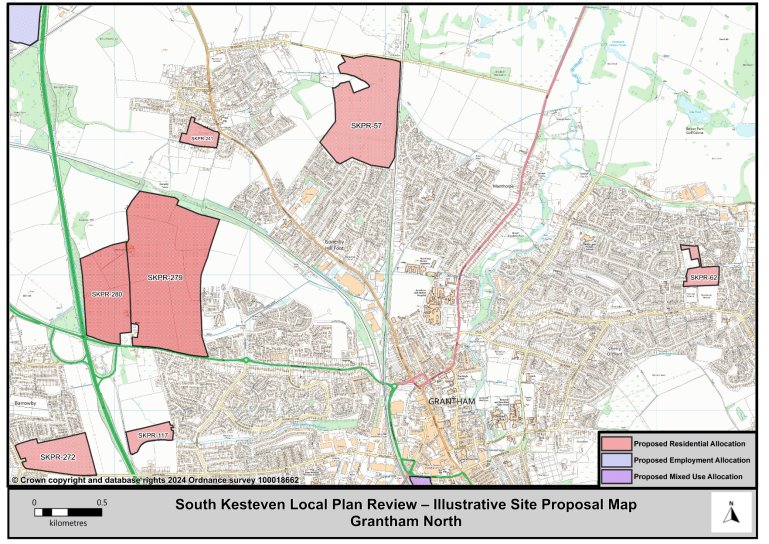
Figure 17: Grantham (North) Illustrative Map
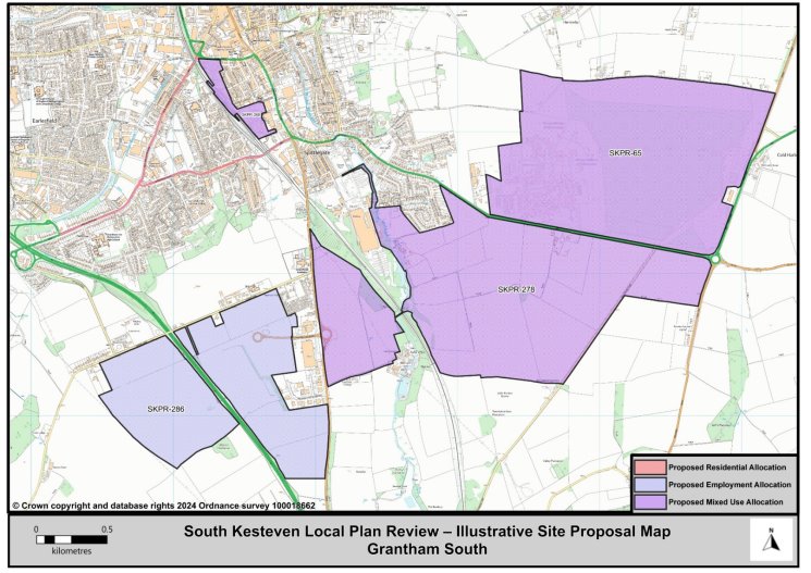
Figure 18: Grantham (South) Illustrative Map
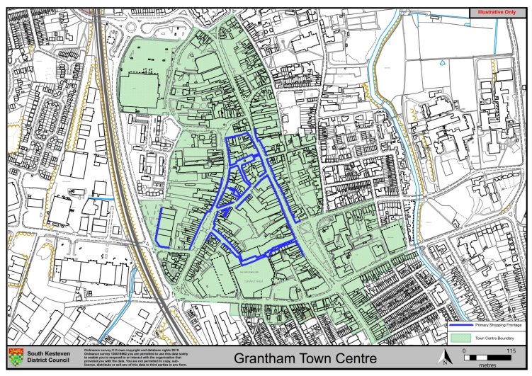
(1) Grantham Town Centre
12.23 The Local Plan will seek to encourage retail proposals that support and enhance Grantham's developing role as a sub-regional shopping and leisure destination. The historic fabric of Grantham's town centre creates good potential for investment, regeneration and enhancement despite it having experienced the national pattern of increased shop vacancies. Grantham's sub-regional status and its distance from the key shopping centres of Peterborough and Nottingham means it is capable of operating at a higher retail level than is currently being achieved. The Council with Historic England have supported improvements to shop fronts within the Conservation Area to help revitalise key elements of the townscape.
12.24 Part of Grantham town centre's under achievement is due to significant expenditure leakage into centres such as Peterborough, Nottingham and even Leicester. Expenditure leakage is the technical term for shoppers exhibiting choice; shoppers choose other locations because of the variety those locations can offer them, which in turn impacts the offers available within the centre not being visited, in this instance Grantham town centre. Grantham is not large enough to re-create itself as another Peterborough or Nottingham, but it can still build a critical mass in terms of its population and look to reinvent and to reinvigorate itself as a sub-regional shopping and leisure destination. Wider local infrastructure issues, such as congestion within the town centre, will be addressed through the delivery of the Local Plan. A Designer Village Outlet has been granted planning permission with expected visitors estimated to be 3 million when fully operational – it is projected that approximately 10% of these will also visit the town centre.
12.25 The policy sets out what will be encouraged within Grantham town centre to enable this shift towards a better shopping and leisure destination not just for the District's resident population, but also workers and visitors.
Policy Type: Minor Changes to Policy
(4) GR4: Grantham Town Centre Policy
The Grantham town centre boundary and the Primary Shopping frontages are defined on the Policies Map (as illustrated below).
Within the town centre, development or reuse of buildings for a range of uses including retail, leisure, offices, food and drink, cultural and residential will be supported.
Primary Shopping Frontages
Within the Primary Shopping frontages proposals for new premises, conversions or change of use to E(a) (shops) will be encouraged, subject to the proposal contributing positively to the character and appeal of the town centre.
Other appropriate E uses will be supported provided that they positively contribute to the Town Centre either through generating footfall or providing supplementary uses, i.e. banks, cafes.
Town Centre Boundary
Within the town centre boundary, proposals for E- uses classesand appropriate residential development on upper floors, provided that the use does not cause undue harm to the character and appeal of the town centre, nor generate "dead shopping frontages".
Proposals supporting the generation of an evening economy within the Town Centre will be encouraged. The re-development of the St Peter's Hill area will be supported provided that proposals encourage footfall into the town centre and support the evening economy.
A sequential approach will be applied to the location of proposals for main town centre uses which prioritises sites within the town centre ahead of edge of centre sites. Out of centre locations will only be considered if sequentially preferable sites are not available.
Retail impact assessments are required to accompany proposals for main town centre uses in edge of centre or out of centre locations where the gross floorspace proposed is above 1,000sqm.
(9) Stamford
12.26 Stamford is the second largest town in South Kesteven. Stamford is located adjacent to the strategically important national north-south route, the A1, meaning cities such as Peterborough and Cambridge are commutable, and London (100 miles away) is also accessible. There are direct rail services to Cambridge, Birmingham, Peterborough and Stanstead airport, and the East Coast Main Line rail network is accessed via Peterborough. The town also acts as a service centre for nearby villages, such as Uffington and Tallington in the District and Great Casterton and Ryhall in Rutland.
12.27 Stamford is noted for its heritage, its architecture, and its essential medieval and Georgian character, which has been used as the backdrop for many film and television productions. The town centre is protected by a Conservation Area (the first in England) and there are many archaeological remains (both designated and undesignated) throughout the town which are an important part of the town's heritage.
12.28 Stamford has a full range of facilities, including a hospital and several doctors' and dentists' practices. Many of the major national retailers have stores in the town, including branches of the leading supermarkets and the major banks. The town also has many local independent and specialist traders providing a variety of goods and services. Stamford also has a market every Friday, selling local produce and a variety of household goods. Education is available in both state and private schools in Stamford at Primary and Secondary level. New College, Stamford offers both further and higher education courses.
12.29 In 2015, South Kesteven District Council commissioned a Capacity and Limits to Growth Study for Stamford. This was commissioned in order to ensure the existing heritage and other important features of Stamford were protected from future inappropriate development options by identifying the less constrained and strategic opportunities for sensitive growth of the town.
12.30 The proposed strategy for Stamford is to focus on growth to the North of the town. This proposal accords with the findings of the Stamford Capacity and Limits to Growth Study, as focusing growth in the north will ensure the historically significant and sensitive landscape to the south of the town is protected whilst the fabric of the town is protected for future generations.
12.31 Existing allocations are proposed to be retained which includes Stamford North (STM1-H1) which will provide a comprehensive sustainable urban extension to the town, and Stamford East (STM1-H2) both sites are expected to deliver 1670 new homes across the plan period up to 2041. An additional allocation at Exeter Fields is proposed which is expected to deliver 180 new homes by 2032.
Policy Type: Minor Changes to Policy
STM1: Stamford Residential Allocations
(54) SKPR-281 (STM1-H1): Stamford North
Indicative Unit Numbers: 1,350
Approximate Density: 30 Dwellings per hectare
The following development principles accompany this allocation:
- A high level masterplan, supported by a detailed development brief, appropriate full transport assessment and phasing plan, is required for the entire site (to include for the land extending into Quarry Farm, Rutland with an additional capacity of 650 dwellings).
- The layout of the development should provide appropriate transport infrastructure measures to encourage walking, cycling and use of public transport in order to maximise opportunities for sustainable modes of transport.
- Safe and convenient highway, footway, cycleway connections shall be provided throughout the site connecting it to local schools, community facilities and into the wider town.
- An East-West road to be provided through from Old Great North Road to Ryhall Road. This should offer mitigation to the town centre from the traffic generated as a result of this development.
- The development shall accommodate specialist housing needs through the provision of retirement housing, extra care or residential care housing.
- The development shall make provision for a new primary school.
- The development shall make provision for contributions towards the expansion or improvement of the adjacent secondary school.
- The development shall make provision for a local centre, to serve the needs of both existing and new residents to the area. The local centre should include the provision of appropriate social and community facilities.
- The development should positively respond to green infrastructure opportunities and provide sensitive landscaping to the northern edge of the site.
- Land to the east of the dismantled railway line should be utilised primarily for the provision of open space and strategic landscaping including surface water drainage features, only in order that the character of this area remains open and verdant.
- The development should provide net gains in biodiversity on site and contribute to wider ecological networks where possible.
- The development will provide appropriate mitigation measures to the Strategic Road Network to be agreed with Highways England.
- This site is within or includes an area of Biodiversity Opportunity. Proposals on this site should incorporate the relevant principles for development within Biodiversity Opportunity Areas set out in New Policy 4: Biodiversity Opportunity and Delivering Measurable Net Gains.
- This site is within or includes a Green Infrastructure Area. Proposals on this site should incorporate the relevant principles for development within Green Infrastructure Areas set out in Policy EN3 Green Infrastructure.
Policy Type: Minor Changes to Policy
(10) SKPR-282 (STM1- H2): Stamford East
Indicative Unit Numbers: 320
Approximate Density: 30 Dwellings per hectare
The following development principles accompany this allocation:
- A comprehensive masterplan is required for the entire site.
- The layout of the development should provide appropriate transport infrastructure measures to encourage walking, cycling and use of public transport in order to maximise opportunities for sustainable modes of transport.
- This site represents a gateway location and this should be recognised in the design and layout of development proposals.
- Highway, footway, cycleway connections should be provided throughout the site which connect the site into the wider area.
- To ensure the development achieves good, high quality design, a design code will be prepared for the site.
- Any contaminated land should be remediated to recognised standards.
- This site is situated within a Minerals Safeguarding Area. A Minerals Assessment will be required as part of any planning application.
- This site is within or includes an area of Biodiversity Opportunity. Proposals on this site should incorporate the relevant principles for development within Biodiversity Opportunity Areas set out in New Policy 4: Biodiversity Opportunity and Delivering Measurable Net Gains.
- This site is within or includes a Green Infrastructure Area. Proposals on this site should incorporate the relevant principles for development within Green Infrastructure Areas set out in Policy EN3 Green Infrastructure.
Summary of Proposed Changes
Policies have been amended to include reference to Biodiversity Opportunity Areas and Green Infrastructure Areas.
Since the adoption of the 2020 Local Plan, part of STM1-H2 Stamford East has been granted planning permission the allocation will be reviewed at the pre-submission stage.
(74) SKPR-266 – Stamford Gateway (Exeter Fields)
Indicative Unit Numbers: 180
Assumed Density: 30 Dwellings per hectare
The following development principles accompany this allocation:
- This site represents a gateway location, and this should be recognised in the design and layout of development proposals.
- Highway, footway, cycleway connections should be provided throughout the site which connect the site into the wider area. This should include footway improvements and crossing facilities on Empingham Road.
- Suitable boundary treatment and noise attenuation shall be provided along the A1 edge of the site.
- This site is situated within a Limestone Minerals Safeguarding Area. Before considering a planning application for this site, a Minerals Assessment will be required.
- This site is within or includes a Green Infrastructure Area. Proposals on this site should incorporate the relevant principles for development within Green Infrastructure Areas set out in Policy EN3 Green Infrastructure.
Summary of Proposed Changes
New site allocations are proposed to meet the minimum housing requirement for South Kesteven over the plan period.
The government's Standard Method establishes a need of 14,020 dwellings from 2021 to 2041, equating to 701 dwellings per annum.
To meet the total housing supply need an additional site has been identified for residential development in Stamford.
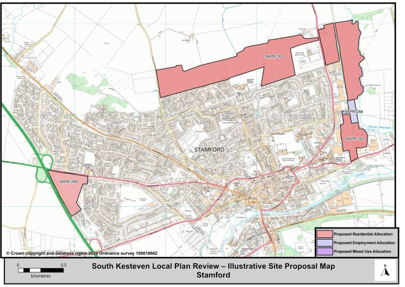
Figure 20: Stamford Illustrative Map
(2) Stamford Town Centre
12.32 The Local Plan will seek to encourage retail proposals that support Stamford's role as one of the three main towns in the District.
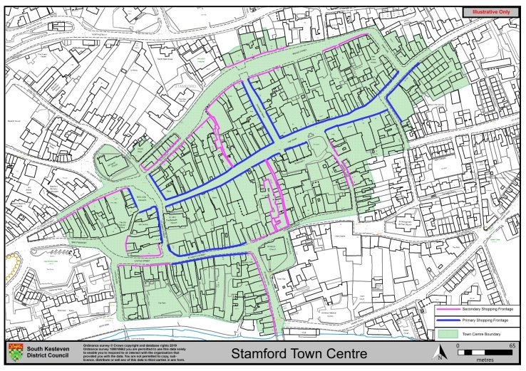
12.33 Stamford has a mostly linear town centre which is situated along High Street between the junctions of St Pauls Street and St John's Street. There are smaller secondary shopping locations running from east to west in St Mary's Street and Broad Street. The majority of the town centre falls within the conservation area and includes a number of listed buildings. Vacancy levels are below the national average.
12.34 The town centre serves the local population and the surrounding rural villages. Stamford's historic status and the unique shopping environment also attract many visitors. The town centre provides a high end retail offer, which is supported by a substantial and diverse leisure and service sector which includes numerous cafes and restaurants.
12.35 These reflect the character of Stamford as a historic Market Town which attracts significant levels of visitor spending. Stamford town centre is confined by its adjacent residential area; the town itself sits within Lincolnshire but adjoins Rutland to the North and West, Peterborough to the South and Northamptonshire to the South-west.
12.36 Policy sets out the types of developments that will be encouraged within Stamford Town centre in order for it to maintain its attractive shopping environment with a good range of independent, specialist shops to serve both visitors and local shoppers and to maintain the town's distinct identity within the district.
Policy Type: Minor Changes to Policy
(2) STM2: Stamford Town Centre Policy
The Stamford town centre boundary, Primary and Secondary Shopping frontages are defined on the Policies Map (and as illustrated below).
- Within the town centre, development or reuse of buildings for a range of uses including retail, leisure, offices, food and drink, cultural and new residential uses will be supported.
- Within the Primary Shopping frontages proposals for new E(a) (shops) will be encouraged, subject to the proposal contributing positively to the character and appeal of the town centre. Other appropriate E use classes will be supported provided that they positively contribute to the town centre either through footfall generating uses or providing supplementary uses, i.e. banks, cafes, etc.
- Within the Primary Shopping frontages proposals for conversion or change of use to E(a) (shops) will be positively encouraged, subject to the proposal contributing positively to the character and appeal of the town centre.
- Within the Secondary Shopping frontages proposals for town centre complementary uses will be supported.
A sequential approach will be applied to the location of proposals for main town centre uses which prioritises sites within the town centre ahead of edge of centre sites. Out of centre locations will only be considered if sequentially preferable sites are not available.
Retail impact assessments are required to accompany proposals for main town centre uses in edge of centre or out of centre locations where the gross floorspace proposed is above 1000sqm.
(3) Bourne
12.37 The market town of Bourne is the third largest settlement in South Kesteven. Bourne is a historically important market town because of its location on the A15 Lincoln to Peterborough route. There are regular bus services to Peterborough via Market Deeping, Stamford and Spalding. Bourne is also important as a service centre for nearby smaller settlements in the south and east of the District, especially those located along the A15 corridor and the edge of the fens. It also provides housing for large numbers of people who commute the 16 miles to Peterborough daily, and to those who commute the 21 miles to Grantham.
12.38 Bourne has a range of facilities, including primary and secondary schools, several public houses, several doctors/ dental practices, a bank and a leisure centre. Some national retailers have stores in the town, including branches of leading supermarkets. The town also has many local independent traders providing a variety of goods and services with the local market being held on a Thursday.
Summary of Proposed Changes
Policy BRN1 has been removed due to being overtaken by events.
There is currently a Neighbourhood Plan being produced for the Parish Area of Bourne. The Council is working with the Neighbourhood Plan Group in terms of directional growth for the area. SKDC has proposed site SKPR-53 (Land at Mill Drove) for allocation in conjunction with the outcomes of the Bourne Neighbourhood Plan Housing Sites Assessment Paper published October 2023.
Bourne Residential Allocations
Policy Type: New Policy
(19) SKPR-53 – Land at Mill Drove
Indicative Unit Numbers: 285 (site numbers reduced due to high risk flood areas).
Assumed Density: 30 Dwellings per hectare.
The following development principles accompany this allocation:
- A comprehensive masterplan is required for the site. All parties shall work together to bring forward a comprehensive plan for the site, including the phasing of development.
- Highway, footway, cycleway connections should be provided throughout the site to the wider town.
- Development should integrate the public right of way along the Carr Dyke into the pedestrian movements throughout and into the site.
- The development proposal should ensure the integration of Carr Dyke as a positive landscape feature and provision of open space and ensure that the requisite easement of the Carr Dyke is provided to allow maintenance of the water feature.
- Landscape screening to the eastern edge of the site will be required to reduce the impact on views into the site from the open countryside.
- The high flood risk area within the centre of the site should not be developed but utilised for open space provision, landscaping and sustainable urban drainage (SUDS), as necessary.
- Screening to the south of the development will be required to minimise conflict with the existing industrial development.
- This site is within or includes a Green Infrastructure Area. Proposals on this site should incorporate the relevant principles for development within Green Infrastructure Areas set out in Policy EN3 Green Infrastructure.
Policy Type: New Policy
(13) SKPR-83 – Land North of Mill Drove
Indicative Unit Numbers: 172
Assumed Density: 30 Dwellings per hectare
The following development principles accompany this allocation:
- A comprehensive masterplan is required for the site.
- Highway, footway, cycleway connections should be provided throughout the site to the wider town.
- Development should integrate the public right of way along the Carr Dyke into the pedestrian movements throughout and into the site.
- The development proposal should ensure the integration of Carr Dyke as a positive landscape feature and provision of open space and ensure that the requisite easement of the Carr Dyke is provided to allow maintenance of the water feature.
- Landscape screening to the northern and eastern edges of the site will be required to reduce the impact on views into the site from the open countryside.
- This site is within or includes an area of Biodiversity Opportunity. Proposals on this site should incorporate the relevant principles for development within Biodiversity Opportunity Areas set out in New Policy 4: Biodiversity Opportunity and Delivering Measurable Net Gains.
- This site is within or includes a Green Infrastructure Area. Proposals on this site should incorporate the relevant principles for development within Green Infrastructure Areas set out in Policy EN3 Green Infrastructure.
Summary of Proposed Changes
New site allocations are proposed to meet the minimum housing requirement for South Kesteven over the plan period. The government's Standard Method establishes a need of 14,020 dwellings from 2021 to 2041, equating to 701 dwellings per annum.
To meet the total housing supply need, two additional sites have been identified for residential development in Bourne.
Policy BRN1-H1 has been removed. Since the adoption of the 2020 Local Plan the existing allocation at Manning Road (BRN1-H1), has since been granted planning permission for 121 new homes therefore is being removed as an allocation.
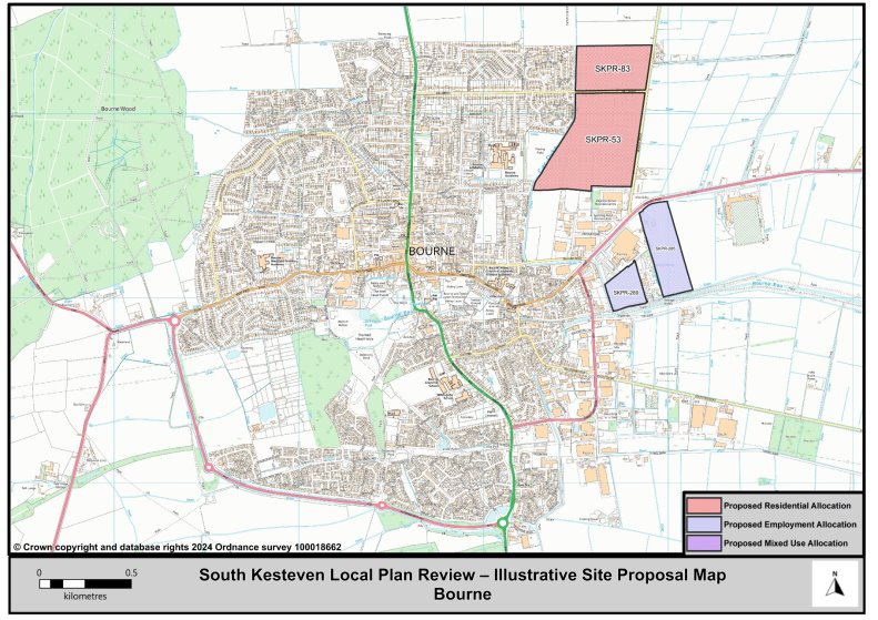
Figure 22: Bourne Illustrative Map
(2) Bourne Town Centre
12.39 The Local Plan will seek to encourage retail proposals that support Bourne's role as one of the three Market Towns within the District.
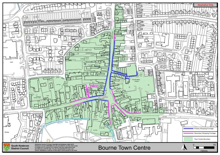
12.40 The shopping centre is predominantly in North Street and West Street. The overall function and growth of the centre is limited by its relatively small footfall and close proximity to the larger centres of Peterborough, Grantham and Stamford.
12.41 Bourne town centre serves the daily shopping and service needs of local residents and serves the smaller rural villages in the surrounding areas. The town has a range of supermarkets, along with many small independent retailers, shops and cafes.
12.42 Policy BRN2 sets out what will be encouraged within Bourne town centre to enable the shift towards a better shopping and leisure destination in order to allow Bourne to maintain its range of convenience and service uses to its population, as well as visitors and workers.
Policy Type: Minor Changes to Policy
(3) BRN2: Bourne Town Centre Policy
The Bourne town centre boundary, Primary and Secondary shopping frontages are defined on the Policies Map (and as illustrated below).
- Within the town centre, development or reuse of buildings for a range of uses including retail, leisure, offices, food and drink, cultural and new residential uses will be supported.
- Within the Primary Shopping frontages proposals for new E(a) (shops) will be encouraged, subject to the proposal contributing positively to the character and appeal of the town centre. Other appropriate E use classes will be supported provided that they positively contribute to the town centre either through footfall generating uses or providing supplementary uses, i.e. banks, cafes, etc.
- Within the Primary Shopping frontages proposals for conversion or change of use to E(a) (shops) will be positively encouraged, subject to the proposal contributing positively to the character and appeal of the town centre.
- Within the Secondary Shopping frontages proposals for town centre complementary uses will be supported.
A sequential approach will be applied to the location of proposals for main town centre uses which prioritises sites within the town centre ahead of edge of centre sites. Out of centre locations will only be considered if sequentially preferable sites are not available.
Retail impact assessments are required to accompany proposals for main town centre uses in edge of centre or out of centre locations where the gross floorspace proposed is above 1000sqm.
(4) The Deepings
12.43 The parishes of Market Deeping and Deeping St James/Frognall together make up the fourth largest settlement within South Kesteven. They are approximately 9 miles north of Peterborough, and 26 miles south of Grantham.
12.44 Many of those living in The Deepings and the immediate area commute to work, with Peterborough offering considerable employment opportunities. Locally, the Northfields Industrial Estate offers an increasing range of employment associated with vehicle garages, warehouse operations, through to communications, navigation and surveillance activity, and the very successful Eventus Business Centre. Elsewhere, a group of industrial properties also exists in Hards Lane, east of Frognall.
12.45 The town acts as the service centre within an identified rural 'hinterland'. Its catchment area is bordered to the north by the villages of Wilsthorpe and Baston, to the east by Deeping St Nicholas, to the south by Northborough and Maxey and the west by Tallington, Barholm and Greatford. This includes villages in the adjoining local authorities of South Holland and Peterborough.
12.46 It is recognised that The Deepings is an attractive and sought after residential location given the range of services and facilities available, and its proximity to Peterborough.
12.47 The draft Local Plan retains the two housing allocations within The Deepings (DEP1-H1 (SKPR-36) and DEP1-H2 (SKPR-37)). In addition, proposes an allocation at Millfield Road (SKPR-144) for 200 new homes and at Priory Farm in Deeping St James (SKPR-26) for 18 new homes. The proposed allocations are expected to deliver a total of 971 new homes over the plan period up to 2041.
DEP1: The Deepings Residential Allocations
Policy Type: Minor Changes to Policy
(7) SKPR-36 (DEP1-H1): Towngate West
Indicative Unit Numbers: 73
Approximate Density: 23 Dwellings per hectare – lower density based on heritage/conservation constraints and to ensure a high quality gateway development
The following development principles accompany this allocation:
- A comprehensive masterplan is required for the site.
- Highway, footway, cycleway connections shall be provided throughout site which connect the site into the wider town.
- This site represents an important gateway location, with heritage and conservation features, this should be recognised in the design and layout of development proposals and proposals should seek to enhance the Peterborough Road frontage.
- Sensitive landscaping shall be incorporated along the western edge of the site.
- To ensure the development achieves good, high quality design, a design code will be prepared for the site.
- This site is situated within a Minerals Safeguarding Area. Before considering a planning application or allocation for this site a Minerals Assessment will be required.
- This site is within or includes a Green Infrastructure Area. Proposals on this site should incorporate the relevant principles for development within Green Infrastructure Areas set out in Policy EN3 Green Infrastructure.
Summary of Proposed Changes
Policy has been amended to include reference to Biodiversity Opportunity Areas and Green Infrastructure Areas.
Policy Type: Minor Changes to Policy
(7) SKPR-37 (DEP1-H2): Linchfield Road
Indicative Unit Numbers: 680
Approximate Density: 30 Dwellings per hectare
The following development principles accompany this allocation:
- A comprehensive masterplan is required for the site.
- Highway, footway, cycleway connections shall be provided throughout the sites which connect the sites into the wider town. The existing footpath running through the sites should be incorporated into the development.
- The development should make contributions towards public transport, education, health and community facilities and open space provision.
- The development shall accommodate specialist housing needs through the provision of retirement housing, extra care or residential care housing.
- Sensitive landscaping shall be incorporated along the eastern edges of the site.
- To ensure the development achieves good, high quality design, a design code will be prepared for the site.
- This site is situated within a Minerals Safeguarding Area. Before considering a planning application or allocation for this site a Minerals Assessment will be required.
- This site is within or includes an area of Biodiversity Opportunity. Proposals on this site should incorporate the relevant principles for development within Biodiversity Opportunity Areas set out in New Policy 4: Biodiversity Opportunity and Delivering Measurable Net Gains.
- This site is within or includes a Green Infrastructure Area. Proposals on this site should incorporate the relevant principles for development within Green Infrastructure Areas set out in Policy EN3 Green Infrastructure.
Summary of Proposed Changes
Policy has been amended to include reference to Biodiversity Opportunity Areas and Green Infrastructure Areas.
Policy Type: New Policy
(132) SKPR-144 Land to the West of Millfield Road
Indicative Unit Numbers: 200
Assumed Density: 30 Dwellings per hectare
The following development principles accompany this allocation:
- A comprehensive masterplan is required for the site.
- Highway, footway, cycleway connections should be provided throughout the site which connect the site into the wider town.
- Noise mitigation shall be incorporated along the A15 aspect of the site.
- Sensitive landscaping shall be incorporated along the northern and western edges of the site.
- This site is situated within a Minerals Safeguarding Area. Before considering a planning application or allocation for this site a Minerals Assessment will be required.
- To ensure the development achieves good, high quality design, a design code will be prepared for the site.
- The development should positively preserve and enhance the Deepings Green Walk and the designated Green Lane along Millfield Road in accordance with the Deepings Neighbourhood Plan.
- This site is within or includes a Green Infrastructure Area. Proposals on this site should incorporate the relevant principles for development within Green Infrastructure Areas set out in Policy EN3 Green Infrastructure.
Policy Type: New Policy
(15) SKPR-26 – Priory Farm Land, Deeping St James
Indicative Unit Numbers: 18
Assumed Density: 30 Dwellings per hectare
The following development principles accompany this allocation:
- The development proposal should seek to preserve and enhance the designated Green Lane that runs along the Southern edge of the site in accordance with the Deepings Neighbourhood Plan.
- Landscape screening to the eastern edge of the site will be required to reduce the impact on views into the site from the open countryside.
- Development of the site should seek to positively incorporate views towards Priory Church of St James and its setting.
- This site is within or includes a Green Infrastructure Area. Proposals on this site should incorporate the relevant principles for development within Green Infrastructure Areas set out in Policy EN3 Green Infrastructure.
- This site is situated within a Minerals Safeguarding Area. Before considering a planning application or allocation for this site a Minerals Assessment will be required.
Summary of Proposed Changes
New site allocations are proposed to meet the minimum housing requirement for South Kesteven over the plan period.
The government's Standard Method establishes a need of 14,020 dwellings from 2021 to 2041, equating to 701 dwellings per annum.
To meet the total housing supply need, two additional sites have been identified for residential development in The Deepings.
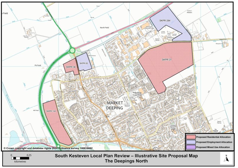
Figure 24: The Deepings (North) Illustrative Map

Figure 25: The Deepings (South) Illustrative Map
(2) Market Deeping Town Centre
12.48 The Local Plan will seek to encourage retail proposals that support Market Deeping's role as one of the three Market Towns within the district.
12.49 The main retail area is in Market Deeping Town Centre and the Deepings centre, the 2 parts being joined through Market Gate and the Precincts. The town centre comprises a cluster of shops focused on Horsegate and the Precinct. There is one large store and several smaller, mostly independent shops.
12.50 The centre falls within a conservation area that includes a number of listed buildings which make up the character of the area. The quality of the centre benefits from individual buildings of varying architectural styles.
12.51 There are few comparison retailers present in the town centre. Given its small scale and its proximity to Stamford and Peterborough the principal role of this town centre is to provide daily services for local residents who will most likely travel to larger town centres for a wider range of services, facilities and comparison retail goods.
12.52 DEP2: Market Deeping Town Centre Policy sets out the types of developments that will be encouraged within Market Deeping Town centre in order for it to maintain its daily shopping and service offer to its local residents and to continue promoting a good town centre quality environment.
Policy Type: Minor Changes to Policy
(3) DEP2: Market Deeping Town Centre Policy
The Market Deeping town centre boundary, Primary and Secondary shopping frontages are defined on the Policies Map (and as illustrated below).
- Within the town centre, development or reuse of buildings for a range of uses including retail, leisure, offices, food and drink, cultural and new residential uses will be supported.
- Within the Primary Shopping frontages proposals for new E(a) (shops) will be encouraged, subject to the proposal contributing positively to the character of the town centre and appeal. Other appropriate E use classes will be supported provided that they positively contribute towards promoting a healthy town centre either through footfall generating uses or providing supplementary uses, i.e. banks, cafes, etc.
- Within the Primary Shopping frontages proposals for conversion or change of use to E(a) (shops) will be positively encouraged, subject to the proposal contributing positively to the character and appeal of the town centre.
- Within the Secondary Shopping frontages proposals for town centre complementary uses will be supported.
A sequential approach will be applied to the location of proposals for main town centre uses which prioritises sites within the town centre ahead of edge of centre sites. Out of centre locations will only be considered if sequentially preferable sites are not available.
Retail impact assessments are required to accompany proposals for main town centre uses in edge of centre or out of centre locations where the gross floorspace proposed is above 1000sqm.

Larger Village Allocations
(1) Ancaster
© Crown copyright and database rights 2018 Ordnance survey 100018662. You are permitted to use this data solely to enable you to respond to, or interact with, the organisation that provided you with the data. You are not permitted to copy, sub-licence, distribute, or sell any of this data to third parties in any form.
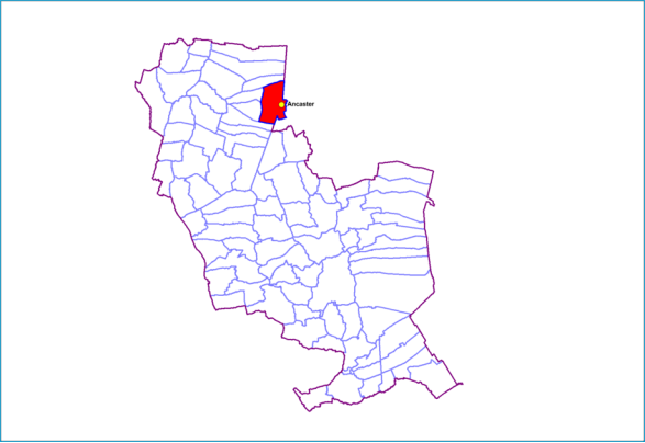
12.53 The village of Ancaster is situated midway between Sleaford (8 miles) and Grantham (8 miles) on the A153 road at its junction with the B6403 (Ermine Street). North of the village, the B6403 (High Dyke) is the dividing line between South and North Kesteven.
12.54 Ancaster has a primary School, Butchers, Doctors Surgery, small Supermarket, Post Office, Public House, and a Petrol Station. There is a small railway station on the Nottingham–Skegness line, and to the West of the village on Willoughby Road (A153) is a holiday park which supports local tourism opportunities.
12.55 There are a number of designated nature conservation sites in the area, including Lincolnshire Wildlife Trust nature reserves, Sites of Special Scientific Interest and Local Wildlife Sites supporting valuable habitats including calcareous and neutral grassland. The churchyard and adjacent nature reserve of Moor Closes are home to tall thrift, a nationally rare plant which is only known to occur on these two sites throughout the UK, and the network of nearby road verges support an important corridor of species-rich grassland sites.
Ancaster Residential Allocations
Summary of Proposed Changes
Policy LV-H1 is to be removed.
Since the adoption of the 2020 Local Plan, LV-H1 Wilsford Lane has been granted planning permission for 96 dwellings therefore is being removed as an allocation.
Status: Minor Changes to Policy
(4) SKPR-271 (LV-H2): Wilsford Lane (SKLP211)
Indicative Unit Numbers: 35
Approximate Density: 16 Dwellings per hectare - lower density based on gateway location and heritage features to the south.
The following development principles accompany this allocation:
- Landscape screening to Southern edge will be required so as to reduce the impact on views into the site from the open countryside.
- There will be no negative impacts on the Wilsford Lane Verge, Ancaster Local Wildlife Site. This site is within or includes an area of Biodiversity Opportunity. Proposals on the site should incorporate the relevant principles for development within Biodiversity Opportunity Areas set out in New Policy 4: Biodiversity Opportunity and Delivering Measurable Net Gains.
- This site is within or includes a Green Infrastructure Area. Proposals on this site should incorporate the relevant principles for development within Green Infrastructure Areas set out in Policy EN3 Green Infrastructure.
- There is the potential for archaeological remains on this site and the appropriate pre-commencement investigations should be carried out.
- This site is situated within a Minerals Safeguarding Areas and a Limestone Mineral Safeguarding Area. Before considering a planning application for this site a Minerals Assessment will be required.
Summary of Proposed Changes
Policy has been amended to include reference to Biodiversity Opportunity Areas and Green Infrastructure Areas.
Policy Type: New Policy
(5) SKPR-58 Land to the East of Ermine Street
Indicative Unit Numbers: 26
Assumed Density: 30 Dwellings per hectare
The following development principles accompany this allocation:
- On the eastern edge of the site a suitable and sensitive boundary treatment will be provided to screen views of the development from the adjacent open countryside.
- Footway connections should be made from the existing play space to the north of the site into the development.
- There is the potential for archaeological remains on this site and the appropriate pre-commencement investigations should be carried out.
- The high flood risk areas to the east of the site should not be developed but utilised for open space provision, landscaping and sustainable urban drainage (SUDS), as necessary.
- This site is situated within a Limestone Mineral Safeguarding Area. Before considering a planning application for this site a Minerals Assessment will be required.
- This site is within or includes an area of Biodiversity Opportunity. Proposals on this site should incorporate the relevant principles for development within Biodiversity Opportunity Areas set out in New Policy 4: Biodiversity Opportunity and Delivering Measurable Net Gains.
- This site is within or includes a Green Infrastructure Area. Proposals on this site should incorporate the relevant principles for development within Green Infrastructure Areas set out in Policy EN3 Green Infrastructure.
Policy Type: New Policy
(5) SKPR-283 – Land off St Martins Way
Indicative Unit Numbers: 65
Assumed Density: 30 Dwellings per hectare.
The following development principles accompany this allocation:
- Pedestrian links, such as footway and cycleway connections into the village from the site to station approach should be incorporated in the development proposal.
- Vehicular access shall be served from St Martin's Way only.
- Development should be set back from Pottergate Road to preserve its rural character and sensitivity.
- Potential landscape impacts should be mitigated through high quality design and landscaping.
- There is the potential for archaeological remains on this site and the appropriate pre-commencement investigates should be carried out.
- This site is within or includes a Green Infrastructure Area. Proposals on this site should incorporate the relevant principles for development within Green Infrastructure Areas set out in Policy EN3 Green Infrastructure.
- This site is situated within a Limestone Mineral Safeguarding Area. Before considering a planning application for this site a Minerals Assessment will be required.
Summary of Proposed Changes
New site allocations are proposed to meet the minimum housing requirement for South Kesteven over the plan period.
The government's Standard Method establishes a need of 14,020 dwellings from 2021 to 2041, equating to 701 dwellings per annum.
To meet the total housing supply need, two additional sites have been identified for residential development in Ancaster.

Figure 27: Ancaster Illustrative Map
(1) Barkston
© Crown copyright and database rights 2018 Ordnance survey 100018662. You are permitted to use this data solely to enable you to respond to, or interact with, the organisation that provided you with the data. You are not permitted to copy, sub-licence, distribute, or sell any of this data to third parties in any form.
12.56 The village of Barkston is situated approximately 4 miles north from the market town of Grantham, and on the A607 road, just south of the A153 to Ancaster.
12.57 Barkston has a primary school, village hall, and a public house. There is also a petrol station with a shop on the main road, and an adjacent hand car wash and mechanic's garage. The village also has open space provision, including allotments, Children's equipped play areas and a Sports field.
Barkston Residential Allocations
Policy Type: New Policy
(5) SKPR-242 Land East of Honington Road
Indicative Unit Numbers: 54
Assumed Density: 25 dwellings per hectare to accommodate conservation area and adjacent listed buildings.
The following development principles accompany this allocation:
- Landscape screening and sensitive design to the northern boundary will be required to reduce the impact on views into the site from the recreational ground.
- The south west corner of the site shall not be developed but utilised for open space provision, landscaping and sustainable urban drainage (SUDS), as necessary. This is to ensure no negative impact to Minnetts Hill and protection of important views towards the Church of St Nicholas and its setting.
- Possible impact on the Conservation Area and adjacent listed buildings shall be considered to mitigate possible harm a low-density residential scheme should be proposed.
- Pedestrian links, such as footway and cycleway connections into the village from the site and towards the recreational ground should be incorporated into the development proposal.
- This site is within or includes a Green Infrastructure Area. Proposals on this site should incorporate the relevant principles for development within Green Infrastructure Areas set out in Policy EN3 Green Infrastructure.
Summary of Proposed Changes
New site allocations are proposed to meet the minimum housing requirement for South Kesteven over the plan period.
The government's Standard Method establishes a need of 14,020 dwellings from 2021 to 2041, equating to 701 dwellings per annum.
To meet the total housing supply need a site has been identified for residential development in Barkston.
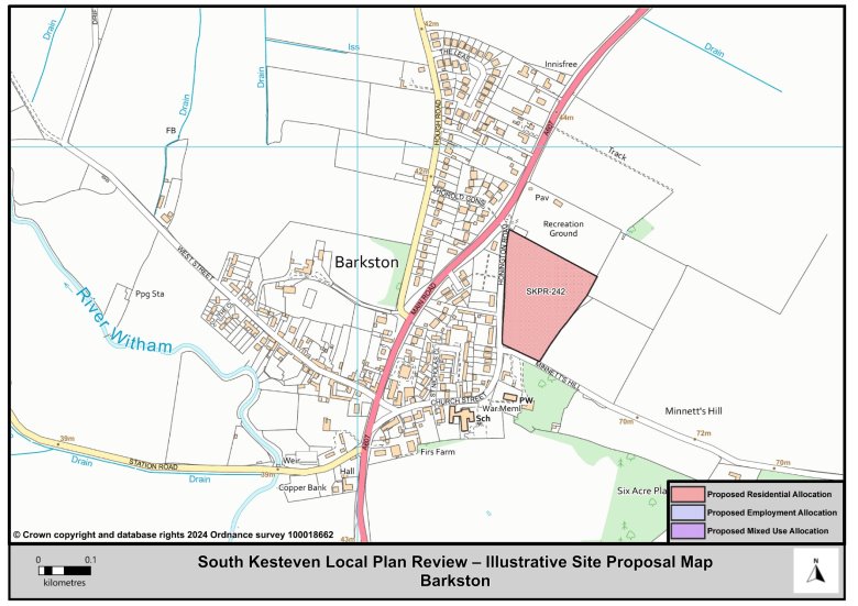
Figure 28: Barkston Illustrative Map
(5) Barrowby
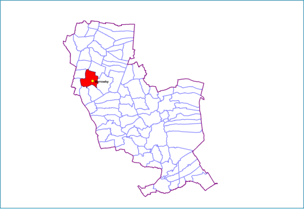
© Crown copyright and database rights 2018 Ordnance survey 100018662. You are permitted to use this data solely to enable you to respond to, or interact with, the organisation that provided you with the data. You are not permitted to copy, sub-licence, distribute, or sell any of this data to third parties in any form.
12.58 The village of Barrowby stands approximately 2 miles west of the town centre of Grantham, on the A52 road to Nottingham and on the west side of the A1.
12.59 The village has an attractive conservation area at its core, and 33 listed buildings within the parish. Barrowby has a Primary School, Public House, Post Office with general store, Butcher's shop, a Memorial Hall, Florist, and a Bistro and Café open on weekend evenings.
12.60 Sport is also popular in the village, with both junior and senior football clubs, plus a cricket team. The Parish Council, in conjunction with the Football Foundation, built a new pavilion on Lowfield sports ground.
12.61 The allocation in Barrowby will deliver up to 270 new dwellings at a maximum density of 35 dwellings per hectare to the south of the village. Part of the site has been completed with 49 new homes delivered in 2021/2022 as part of an affordable housing scheme.
Barrowby Residential Allocations
Policy Type: Minor Changes to Policy
(7) SKPR-272 (LV-H3): Low Road
Land is allocated for up to 270 new dwellings at a maximum density of 35 dwellings per hectare
The following development principles accompany this allocation:
- A masterplan is required for the entire site. All parties shall work together to bring forward a comprehensive plan for the site, including the phasing of development. The masterplan is to be agreed by the Council following consultation with the local community. Detailed proposals will only be permitted where these are in accordance with the agreed masterplan.
- Additional treatment capacity is required at waste water treatment works and new discharge permits are required for water quality targets. This should be incorporated early on in the development of scheme specifics as part of a scheme wide delivery strategy which demonstrates that capacity is available or could be made available to serve the development subject to phasing.
- The masterplan and development proposals will incorporate a substantial landscape and boundary treatment for the southern and eastern edges of the site allocation. No development will be permitted beyond the site allocation.
- The phasing of the development shall occur in accordance with the Infrastructure Delivery Plan, with particular relevance to education and capacity at Barrowby Primary school.
- The masterplan and development proposals will provide suitable and appropriate residential amenity buffers to the eastern edge in respect of the electricity pylons and the A1 and to the southern edge in respect of the high pressure gas line.
- Potential landscape impacts should be mitigated through high quality design and landscaping.
- The development should provide net gains in biodiversity on site and contributed to wider ecological networks where possible.
- This site is within or includes a Green Infrastructure Area. Proposals on this site should incorporate the relevant principles for development within Green Infrastructure Areas set out in Policy EN3 Green Infrastructure.
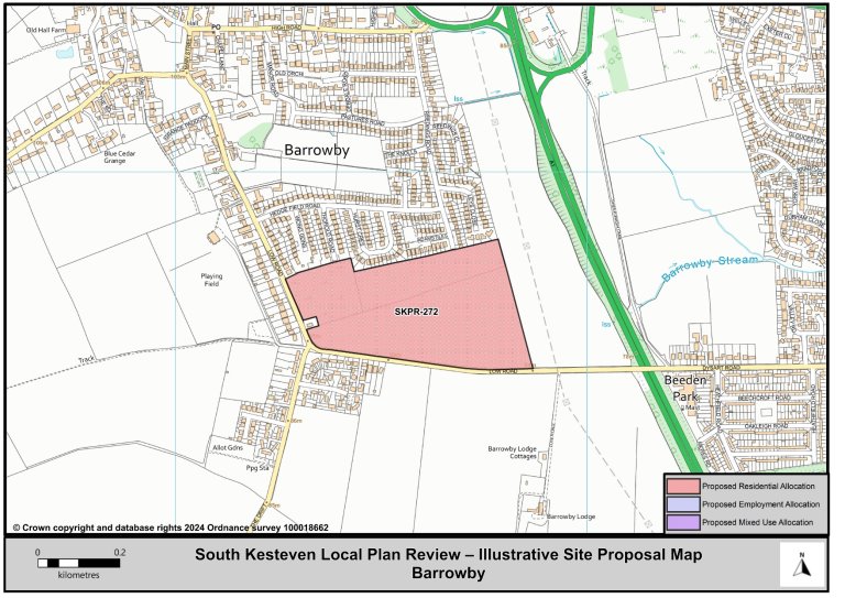
Figure 29: Barrowby Illustrative Map
(1) Baston
12.62 The village of Baston is located on the edge of South Kesteven. It is 12 miles north of the city of Peterborough and 25 miles away from Grantham. The northern boundary of the parish lies on the River Glen, beyond which is Thurlby. To the south is Langtoft and in the west is Greatford.
12.63 Baston has a village Shop with a Post Office, a Village Hall, a community centre and two Public Houses. The village also has open space provision, including sports pitches and allotments. There is also an independent school for children aged 3 to 18 years.
Baston Residential Allocations
Policy Type: New Policy
(16) SKPR-109 – Land Fronting Deeping Road
Indicative Unit Numbers: 86
Assumed Density: 30 Dwellings per hectare
The following development principles accompany this allocation:
- This site represents a gateway location and this should be recognised in the design and layout of development proposals.
- Development proposals will incorporate a substantial landscape and boundary treatment for the southern edge of the site allocation.
- Pedestrian links, such as footway and cycleway connections into the village from the site along Deeping Road should be incorporated in the development proposal including connections and improvements to the public right of way to the north of the site.
- There is the potential for archaeological remains on this site and the appropriate pre-commencement investigates should be carried out.
- This site is within or includes a Green Infrastructure Area. Proposals on this site should incorporate the relevant principles for development within Green Infrastructure Areas set out in Policy EN3 Green Infrastructure.
- This site is situated within a Minerals Safeguarding Area. Before considering a planning application for this site a Minerals Assessment will be required.
Summary of Proposed Changes
New site allocations are proposed to meet the minimum housing requirement for South Kesteven over the plan period.
The government's Standard Method establishes a need of 14,020 dwellings from 2021 to 2041, equating to 701 dwellings per annum.
To meet the total housing supply need, a site has been identified for residential development in Baston.
Figure 30: Baston Illustrative Map
(1) Billingborough
© Crown copyright and database rights 2018 Ordnance survey 100018662. You are permitted to use this data solely to enable you to respond to, or interact with, the organisation that provided you with the data. You are not permitted to copy, sub-licence, distribute, or sell any of this data to third parties in any form.
12.64 The village of Billingborough is situated approximately 10 miles north from Bourne and 10 miles south from Sleaford; it is on the B1177 fen edge road between Horbling and Pointon just south of the A52.
12.65 Billingborough has an industrial heritage and has existing industrial areas. The village has a Primary School and pre-school, Public House, a post office which incorporates a convenience store, two small Supermarket, and a Butchers shop. Further facilities in the village include a Village Hall, a motor repair services, hairdressers, police and fire stations and various other small businesses.
Billingborough Residential Allocations
Policy Type: New Policy
(6) SKPR-61 and SKPR-103 – Former Aveland School, and Land to the West of Pointon Road
Indicative Unit Numbers: 140
Assumed Density: 30 Dwellings per hectare
The following development principles accompany this allocation:
- A comprehensive masterplan is required for the site. All parties shall work together to bring forward a comprehensive plan for the site, including the phasing of development.
- Pedestrian links, such as footway and cycleway connections into the village at both north and east boundaries of the site should be incorporated into the development proposal.
- Connections to the existing allotments to the north of the site should be provided.
- Development proposals should make good use of the two potential access points into the site from Pointon Road and Birthorpe Road.
- Views towards the church should be incorporated into the design and layout of the site.
- Development should be set back from the historic hedgerow to south of the site.
- This site is within or includes an area of Biodiversity Opportunity. Proposals on this site should incorporate the relevant principles for development within Biodiversity Opportunity Areas set out in New Policy 4: Biodiversity Opportunity and Delivering Measurable Net Gains.
- This site is within or includes a Green Infrastructure Area. Proposals on this site should incorporate the relevant principles for development within Green Infrastructure Areas set out in Policy EN3 Green Infrastructure.
Summary of Proposed Changes
New site allocations are proposed to meet the minimum housing requirement for South Kesteven over the plan period.
The government's Standard Method establishes a need of 14,020 dwellings from 2021 to 2041, equating to 701 dwellings per annum.
To meet the total housing supply need, a site has been identified for residential development in Billingborough.
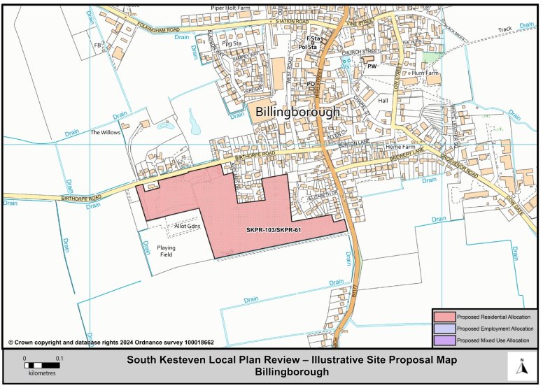
Figure 31: Billingborough Illustrative Map
(2) Caythorpe and Frieston
© Crown copyright and database rights 2018 Ordnance survey 100018662. You are permitted to use this data solely to enable you to respond to, or interact with, the organisation that provided you with the data. You are not permitted to copy, sub-licence, distribute, or sell any of this data to third parties in any form.
12.66 Caythorpe and Frieston are joined as a Larger Village because there is a clear join of these settlements (i.e., there is no physical gap between them). The village is situated on the A607, approximately 3 miles south from Leadenham and 8 miles (13 km) north from Grantham.
12.67 Caythorpe has a local village shop, a post office and a village hall. Caythorpe also has two public houses, a police office, a doctor's surgery and a mobile library, along with open space and recreational provision.
12.68 There are no proposed allocations in Caythorpe and Frieston.
(24) Claypole
12.69 Claypole lies on the northern-western fringe of South Kesteven. The village of Claypole is situated just east of the A1 between Grantham and Newark, approximately 4 miles south-east of Newark on Trent and 13 miles from Grantham.
12.70 Claypole has a Primary School, Public House, and a Village Hall. There is also a Village shop, a Butchers shop, Hairdressers, and a Café, along with allotments, open space and recreational provisions.
12.71 Claypole Parish Council (as the qualifying body) is in the process of preparing a Neighbourhood Plan for the Claypole Parish area.
12.72 There are no proposed allocations in Claypole.
(8) Colsterworth
© Crown copyright and database rights 2018 Ordnance survey 100018662. You are permitted to use this data solely to enable you to respond to, or interact with, the organisation that provided you with the data. You are not permitted to copy, sub-licence, distribute, or sell any of this data to third parties in any form.
12.73 Colsterworth is located 7 miles south of Grantham and 12 miles north of Stamford, between the River Witham and the A1. The older core of the village runs north-south on a limestone ridge above the flood plain of the Witham and along the route of the original Great North Road.
12.74 The village has a Primary School, pre-school groups, a medical practice, a mobile Post Office service, a Village Hall, and Social Club, a general store and a small Supermarket. There are also well equipped play / recreation grounds, open space and allotments.
12.75 There is a Neighbourhood Plan for Colsterworth and District which was made part of the Development Plan for South Kesteven in September 2017.
12.76 Colsterworth is home to Woolsthorpe Manor which is an acknowledged international attraction.
Colsterworth Residential Allocation
Policy Type: New Policy
(67) SKPR-120 Land at the East of Stamford Road
Indicative Unit Numbers: 70
Assumed Density: 30 Dwellings per hectare
The following development principles accompany this allocation
- A public right of way passes through the site – this shall be retained and incorporated into the development of the site where possible.
- Pedestrian links, such as footway and cycleway connections into the village from the site should be incorporated in the development proposal.
- Landscaping screening to the southern edge will be required to reduce the impact on views from the open countryside.
- This site is situated within a Limestone Mineral Safeguarding Area. Before considering a planning application for this site a Minerals Assessment will be required.
- This site is within or includes an area of Biodiversity Opportunity. Proposals on this site should incorporate the relevant principles for development within Biodiversity Opportunity Areas set out in New Policy 4: Biodiversity Opportunity and Delivering Measurable Net Gains.
Summary of Proposed Changes
New site allocations are proposed to meet the minimum housing requirement for South Kesteven over the plan period.
The government's Standard Method establishes a need of 14,020 dwellings from 2021 to 2041, equating to 701 dwellings per annum.
To meet the total housing supply need, a site has been identified for residential development in Colsterworth.
Policy LV-H4 is to be removed. Since the adoption of the 2020 Local Plan, LV-H4 Bourne Road, has been granted planning permission for 70 dwellings therefore is being removed as an allocation.
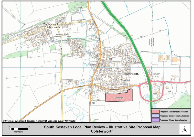
Figure 32: Colsterworth Illustrative Map
(3) Corby Glen
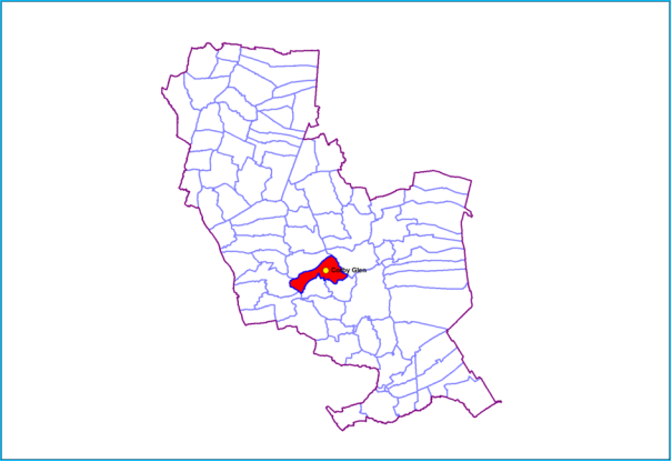
© Crown copyright and database rights 2018 Ordnance survey 100018662. You are permitted to use this data solely to enable you to respond to, or interact with, the organisation that provided you with the data. You are not permitted to copy, sub-licence, distribute, or sell any of this data to third parties in any form.
12.77 The village of Corby Glen is set in wooded countryside 12 miles south of Grantham and 15 miles north of Stamford with the village lying on the A151 Colsterworth to Bourne road. The River Glen flows through the village.
12.78 Corby Glen has two schools (both a primary and a secondary academy), a playgroup, two village shops, and a post office, Community Centre, and a Village Hall. Other facilities include two Doctor's Surgeries, a Fire Station, two Public Houses, Café, a mobile library, and open space and recreational provision.
Corby Glen Residential Allocation
Policy Type: New Policy
(62) SKPR-247 – Land North of Bourne Road
Indicative Unit Numbers: 144
Assumed Density: 30 Dwellings per hectare
The following development principles accompany this allocation:
- A public right of way passes through the site – this should be retained along with the existing hedgerow feature and be incorporated into the development of the site where possible.
- Pedestrian links, such as footway and cycleway connections into the centre of village from the site should be incorporated in the development proposal.
- Frontage footway to be provide on Bourne Road with existing ditch culverted.
- Sensitive landscaping screening to the north east edge of the site will be required to protect the views from the open countryside.
- Potential landscape impacts should be mitigated through high quality design and landscaping.
- This site is situated within a Limestone Mineral Safeguarding Area. Before considering a planning application for this site a Minerals Assessment will be required.
- This site is within or includes an area of Biodiversity Opportunity. Proposals on this site should incorporate the relevant principles for development within Biodiversity Opportunity Areas set out in New Policy 4: Biodiversity Opportunity and Delivering Measurable Net Gains.
- This site is within or includes a Green Infrastructure Area. Proposals on this site should incorporate the relevant principles for development within Green Infrastructure Areas set out in Policy EN3 Green Infrastructure.
Summary of Proposed Changes
New site allocations are proposed to meet the minimum housing requirement for South Kesteven over the plan period.
The government's Standard Method establishes a need of 14,020 dwellings from 2021 to 2041, equating to 701 dwellings per annum.
To meet the total housing supply need, a site has been identified for residential development in Corby Glen.
Policy LV-H5 is to be removed. Since the adoption of the 2020 Local Plan, LV-H5 Swinstead Road/Bourne Road has been granted planning permission for 265 dwellings therefore is being removed as an allocation.
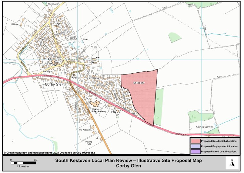
Figure 33: Corby Glen Illustrative Map
(5) Great Gonerby
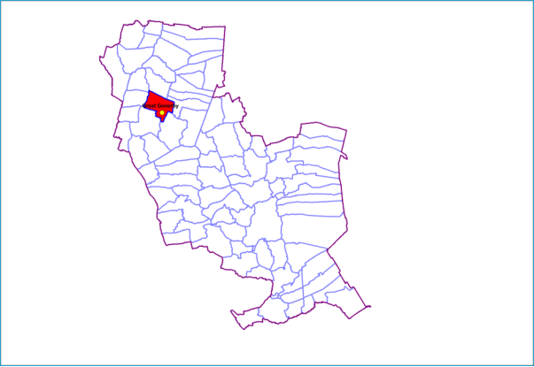
© Crown copyright and database rights 2018 Ordnance survey 100018662. You are permitted to use this data solely to enable you to respond to, or interact with, the organisation that provided you with the data. You are not permitted to copy, sub-licence, distribute, or sell any of this data to third parties in any form.
12.79 The village of Great Gonerby is situated less than 1 mile north from Grantham. The village overlooks the Vale of Belvoir and is situated close to the A1.
12.80 Great Gonerby has a Primary School, a pre-school, a playgroup, a grocery store and a Post Office/Shop. Further facilities include a Public House, a Memorial Hall, a Social Club and a playing field with play area and floodlit multi-sport facility; along with open spaces and equipped play areas.
Great Gonerby Residential Allocation
Policy Type: New Policy
(54) SKPR-241 – Land Off Church Lane
Indicative Unit Numbers: 86
Assumed Density: 30 Dwellings per hectare
The following development principles accompany this allocation
- Pedestrian links, such as footway and cycleway connections into the village and towards the public footpath to the south of the site should be incorporated into the development proposal.
- Highway improvements to Church Lane will be required.
- Development of the site should seek to positively incorporate views towards the St Sebastian's Church and its setting.
- Retain and incorporate important on site features, such as trees and hedgerows, where possible.
- This site is within or includes a Green Infrastructure Area. Proposals on this site should incorporate the relevant principles for development within Green Infrastructure Areas set out in Policy EN3 Green Infrastructure.
Summary of Proposed Changes
New site allocations are proposed to meet the minimum housing requirement for South Kesteven over the plan period.
The government's Standard Method establishes a need of 14,020 dwellings from 2021 to 2041, equating to 701 dwellings per annum.
To meet the total housing supply need, a site has been identified for residential development in Great Gonerby.
Policy LV-H6 has been removed as the development is now complete.

Figure 34: Great Gonerby Illustrative Map
(2) Harlaxton
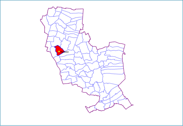
© Crown copyright and database rights 2018 Ordnance survey 100018662. You are permitted to use this data solely to enable you to respond to, or interact with, the organisation that provided you with the data. You are not permitted to copy, sub-licence, distribute, or sell any of this data to third parties in any form.
12.81 The village of Harlaxton lies on the edge of the Vale of Belvoir and just off the A607, 2 miles south-east from Grantham and 12 miles north-east from Melton Mowbray.
12.82 Harlaxton's facilities include a Public House, Post Office within the local store, Primary School, a Doctor's surgery and Village Hall. There are also local sports clubs, alongside the open space provision.
12.83 Harlaxton is home to Harlaxton Manor which is an important heritage asset and a Grade 1 listed building.
Harlaxton Residential Allocations
Policy Type: New Policy
(4) SKPR-74 – The Land West of The Drift
Indicative Unit Numbers: 24
Assumed Density: 30 Dwellings per hectare
The following development principles accompany this allocation:
- Pedestrian links, such as footway and cycleway connections into the centre of village from the site should be incorporated in the development proposal.
- Development should be set back from the large mature trees to the east of the site.
- This site is within or includes a Green Infrastructure Area. Proposals on this site should incorporate the relevant principles for development within Green Infrastructure Areas set out in Policy EN3 Green Infrastructure.
Summary of Proposed Changes
New site allocations are proposed to meet the minimum housing requirement for South Kesteven over the plan period.
The government's Standard Method establishes a need of 14,020 dwellings from 2021 to 2041, equating to 701 dwellings per annum.
To meet the total housing supply need, a site has been identified for residential development in Harlaxton.
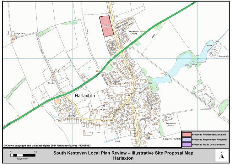
Figure 35: Harlaxton Illustrative Map
(2) Langtoft
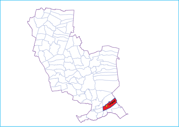
© Crown copyright and database rights 2018 Ordnance survey 100018662. You are permitted to use this data solely to enable you to respond to, or interact with, the organisation that provided you with the data. You are not permitted to copy, sub-licence, distribute, or sell any of this data to third parties in any form.
12.84 The Village of Langtoft lies on the A15 road, about 10 miles (16 km) north from Peterborough and about 8 miles (13 km) east from Stamford, and on the edge of The Fens.
12.85 Langtoft has a Primary School, pre-school, Village Hall, Post Office, Newsagents, a mini-Supermarket, and a Public House. Other facilities include a mobile library service, Hairdressers, and motor repairs and servicing facilities. Langtoft also has allotments, fully equipped children's play area, a Pavilion and recreational provision.
Langtoft Residential Allocations
Policy Type: New Policy
(22) SKPR-71 - Land North of Dickens Close, Stowe Road
Indicative Unit Numbers: 55
Assumed Density: 30 Dwellings per hectare
The following development principles accompany this allocation:
- A suitable and sensitive boundary treatment will be required on the western and northern edges of the site to screen views from the open countryside.
- Potential landscape impacts should be mitigated through high quality design and landscaping.
- This site is within or includes a Green Infrastructure Area. Proposals on this site should incorporate the relevant principles for development within Green Infrastructure Areas set out in Policy EN3 Green Infrastructure.
Summary of Proposed Changes
New site allocations are proposed to meet the minimum housing requirement for South Kesteven over the plan period.
The government's Standard Method establishes a need of 14,020 dwellings from 2021 to 2041, equating to 701 dwellings per annum.
To meet the total housing supply need, a site has been identified for residential development in Langtoft.
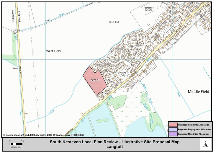
Figure 36:Langtoft Illustrative Map
(1) Long Bennington
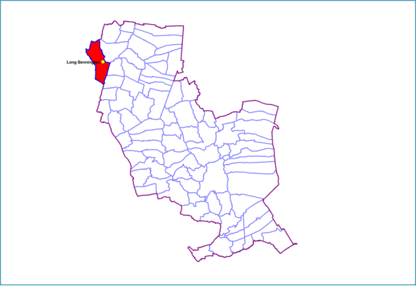
© Crown copyright and database rights 2018 Ordnance survey 100018662. You are permitted to use this data solely to enable you to respond to, or interact with, the organisation that provided you with the data. You are not permitted to copy, sub-licence, distribute, or sell any of this data to third parties in any form.
12.86 Long Bennington is located along a 1.7 mile length of the Old Great North Road, which was by-passed by the A1 in 1967. It is 7 miles north of Grantham and 6 miles south of Newark.
12.87 There is a Primary School, a pre-school, a Nursery, Doctors Surgery, Village Hall, a mini-Supermarket and three Public Houses. There is a large range of facilities in Long Bennington including a mobile Post Office service in the Village Hall, a mobile Library service, Hairdressers, Café, Motor Repairs service. There is also a large sports field/pavilion, open spaces and recreational provision.
12.88 The village has 2 employment areas, Long Bennington Business Park to the North of the village and the larger Roseland Industrial Park which straddles the border with Leicestershire at the Southern edge of the Parish.
12.89 There is a Neighbourhood Plan for Long Bennington which was made part of the Development Plan for South Kesteven in September 2017.
Long Bennington Residential Allocations
Policy Type: Minor Changes to Policy
(2) SKPR-273 (LV-H7): Main Road (South)
Indicative Unit Numbers: 50
Approximate Density: 30 dwellings per hectare.
The following development principles accompany this allocation:
- Noise impact from the A1 shall be considered and suitable mitigation provided.
- Screening along the western and southern edges will be required.
- This site is within or includes a Green Infrastructure Area. Proposals on this site should incorporate the relevant principles for development within Green Infrastructure Areas set out in Policy EN3 Green Infrastructure.
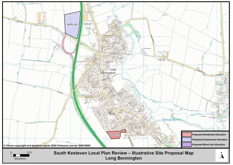
Figure 37: Long Bennington Illustrative Map
(1) Morton
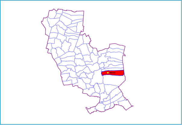
© Crown copyright and database rights 2018 Ordnance survey 100018662. You are permitted to use this data solely to enable you to respond to, or interact with, the organisation that provided you with the data. You are not permitted to copy, sub-licence, distribute, or sell any of this data to third parties in any form.
12.90 The village of Morton lies 2 miles north of Bourne, and 14 miles south-east of Grantham. The village is in two parts, on each side of the fen-edge road (the A15). To the fenward side is Morton and to the upland side is Hanthorpe.
12.91 Morton has a Primary School, Food Shop, village hall, Post Office, a public house, pre-School, mobile library. Additional facilities include open spaces and fully equipped play areas.
Morton Residential Allocation
Policy Type: Minor Changes to Policy
(1) SKPR-274 LV-H9: Folkingham Road
Indicative Unit Numbers: 71
Approximate Density: 25 dwellings per hectare to accommodate conservation area and adjacent listed buildings.
The following development principles accompany this allocation:
- Possible impact on the Conservation Area and adjacent listed buildings shall be considered and to mitigate possible harm a low-density residential scheme should be proposed.
- On the northern edge of the site a suitable and sensitive boundary treatment will be provided to screen views of the development from the adjacent open countryside.
- Should access to the site come via the A15 any development should be set back from the road aspect and suitable landscape screening provided.
- Pedestrian and/or cycle connections from the centre of the site onto High Street shall be provided.
- Development of this site will need to be phased in accordance with the Infrastructure Delivery Plan so that necessary infrastructure requirements can be accommodated.
- This site is within or includes an area of Biodiversity Opportunity. Proposals on this site should incorporate the relevant principles for development within Biodiversity Opportunity Areas set out in New Policy 4: Biodiversity Opportunity and Delivering Measurable Net Gains.
- This site is within or includes a Green Infrastructure Area. Proposals on this site should incorporate the relevant principles for development within Green Infrastructure Areas set out in Policy EN3 Green Infrastructure.
Summary of Proposed Changes
Policy LV-H9 is considered robust and minor amendments to include reference to the area of Biodiversity Opportunity Areas and Green Infrastructure Areas is proposed at this stage.
Since the adoption of the 2020 Local Plan LV-H9 has been granted outline planning permission for 71 dwellings.
Policy Type: New Policy
(3) SKPR-135 Land to the South of Edenham Road
Indicative Unit Numbers: 48
Assumed Density: 30 Dwellings per hectare
The following development principles accompany this allocation:
- Pedestrian links, such as footway or cycleway improvements into the village along Hanthorpe Road should be provided by the development.
- The public right of way which runs along the southern edge of the site should be retained and connections incorporated into the development, where possible.
- A suitable and sensitive boundary treatment will be required on the western and southern edges of the site to screen views from the open countryside.
- This site is within or includes a Green Infrastructure Area. Proposals on this site should incorporate the relevant principles for development within Green Infrastructure Areas set out in Policy EN3 Green Infrastructure.
Summary of Proposed Changes
New site allocations are proposed to meet the minimum housing requirement for South Kesteven over the plan period.
The government's Standard Method establishes a need of 14,020 dwellings from 2021 to 2041, equating to 701 dwellings per annum.
To meet the total housing supply need, an additional site has been identified for residential development in Morton.
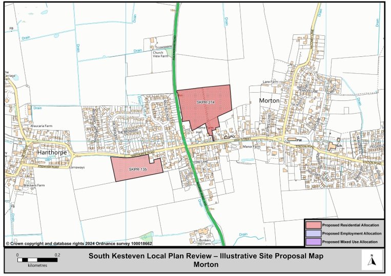
Figure 38: Morton Illustrative Map
(3) South Witham
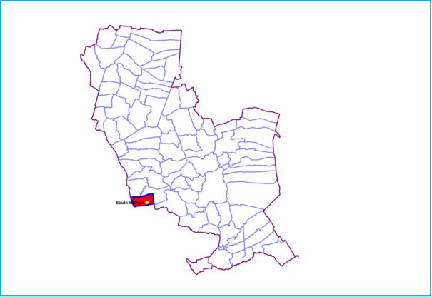
© Crown copyright and database rights 2018 Ordnance survey 100018662. You are permitted to use this data solely to enable you to respond to, or interact with, the organisation that provided you with the data. You are not permitted to copy, sub-licence, distribute, or sell any of this data to third parties in any form.
12.92 The village of South Witham is located 10 miles south of Grantham and 10 miles east of Melton Mowbray.
12.93 South Witham has a village hall, a primary school and Nursery, two local shops (one with a post office), two public houses and a mobile library and Post Office services. Additional facilities include allotments, sports fields, children's equipped play area, and other recreational facilities.
South Witham Residential Allocations
Policy Type: Minor Changes to Policy
(3) SKPR-275 (LV-H10): Thistleton Lane and Mill Lane
Indicative Unit Numbers: 34
Approximate Density: 30 dwellings per hectare.
The following development principles accompany this allocation:
- A comprehensive masterplan is required for the site.
- Reopening of redundant railway line as a pedestrian route should be considered in the development proposal.
- Priority will be given to the redevelopment of the previously developed land on this site.
- Development proposals should make good use of the two potential access points into the site.
- On the western edge of the site a suitable and sensitive boundary treatment will be provided to screen views of the development from the adjacent open countryside.
- A buffer shall be provided along the western edge of the site. This buffer shall screen future residential occupiers of the site from the noise and nuisances of the adjacent quarry. The provision of the buffer will ensure the redevelopment of this site does not impact on the continued operations at the quarry.
- Pedestrian links, such as footway connections into the village from the site should be incorporated in the development proposal.
- That development should seek to improve biodiversity and minimise any impact on South Witham Quarry RIGS/cLGS.
- This site is situated within a Minerals Safeguarding Area and Limestone Minerals Safeguarding Area. Before considering a planning application for this site, a Minerals Assessment will be required.
- This site is within or includes a Green Infrastructure Area. Proposals on this site should incorporate the relevant principles for development within Green Infrastructure Areas set out in Policy EN3 Green Infrastructure.
Summary of Proposed Changes
Policy has been amended to include reference to Biodiversity Opportunity Areas and Green Infrastructure Areas.
Policy Type: Minor Changes to Policy
(7) SKPR-192 and SKPR-276 (LV-H11): Land North of High Street
Indicative unit numbers:138
Approximate Density: 30 dwellings per hectare
The following development principles accompany this allocation:
- A comprehensive masterplan is required for the site.
- On the western edge of the site a suitable and sensitive boundary treatment will be provided to screen views of the development from the adjacent open countryside.
- Pedestrian links, such as footway and cycleway connections into the village from the site should be incorporated in the development proposal to link to existing footway on High Street.
- Footway connections should be made into the existing play space to the north east of the site from the development.
- A buffer should be provided along the southern and western edges of the site. This buffer should screen future residential occupiers of the site from the noise and nuisances of the adjacent quarry. The provision of the buffer will ensure the redevelopment of this site does not impact on the continued operations at the quarry.
- This site is situated within a Minerals Safeguarding Area and Limestone Minerals Safeguarding Area. Before considering a planning application for this site, a Minerals Assessment will be required.
- This site is within or includes an area of Biodiversity Opportunity. Proposals on this site should incorporate the relevant principles for development within Biodiversity Opportunity Areas set out in New Policy 4: Biodiversity Opportunity and Delivering Measurable Net Gains.
- This site is within or includes a Green Infrastructure Area. Proposals on this site should incorporate the relevant principles for development within Green Infrastructure Areas set out in Policy EN3 Green Infrastructure.
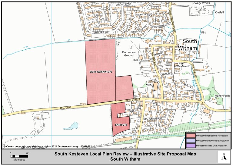
Figure 39: South Witham Illustrative Map
(9) Thurlby and Northorpe
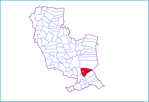
© Crown copyright and database rights 2018 Ordnance survey 100018662. You are permitted to use this data solely to enable you to respond to, or interact with, the organisation that provided you with the data. You are not permitted to copy, sub-licence, distribute, or sell any of this data to third parties in any form.
12.94 Thurlby and Northorpe are joint as a Larger Village because there is a clear join of these settlements (i.e., there is no physical gap between them). The village of Thurlby is divided by the A15 road, 2 miles south from the town of Bourne, on the boundary of the Lincolnshire Fens and the Kesteven Uplands.
12.95 Thurlby has the Grade I listed Parish Church of St Firmin, the village hall and a public house to the east of the A15. There is a shop with a post office, aa Primary School, pre-school, Village Hall, Public House and a Social Club. There is also a Children's equipped play area and sports field at Lawrance Park.
12.96 A Neighbourhood Plan for Thurlby was made part of the development plan for South Kesteven in March 2019.
Thurlby and Northorpe Residential Allocations
Policy Type: Minor Changes to Policy
(59) SKPR-277 (LV-H12): Part of Elm Farm Yard
Indicative Unit Numbers: 50
Approximate Density: 25 dwellings per hectare
The following development principles accompany this allocation:
- Access should not be sought from the A15.
- On the southern and western edges of the site a suitable and sensitive boundary treatment will be provided to screen views of the development from the adjacent open countryside.
- Pedestrian links, such as footway connections into village from the site should be incorporated in the development proposals. This should include safe pedestrian connectivity east and west of the A15 to village facilities.
- This site is within or includes a Green Infrastructure Area. Proposals on this site should incorporate the relevant principles for development within Green Infrastructure Areas set out in Policy EN3 Green Infrastructure.
Summary of Proposed Changes
Policy has been amended to include reference to Biodiversity Opportunity Areas and Green Infrastructure Areas.
Policy Type: New Policy
(69) SKPR-56 – Land at Obthorpe Lane
Indicative Unit Numbers: 86
Assumed Density: 30 Dwellings per hectare
The following development principles accompany this allocation:
- A public right of way runs along the eastern edge of the site, this should be retained and connections incorporated into the development, where possible.
- Vehicular access to the site should be positioned on Obthorpe Lane.
- Pedestrian links, such as footway and cycleway connections into the village from the site, should be incorporated into the development proposal by linking to the existing footway on Obthorpe Lane.
- On the southern edge of the site a suitable and sensitive boundary treatment will be provided to screen views of the development from the adjacent open countryside.
- This site is within or includes a Green Infrastructure Area. Proposals on this site should incorporate the relevant principles for development within Green Infrastructure Areas set out in Policy EN3 Green Infrastructure.
Summary of Proposed Changes
New site allocations are proposed to meet the minimum housing requirement for South Kesteven over the plan period.
The government's Standard Method establishes a need of 14,020 dwellings from 2021 to 2041, equating to 701 dwellings per annum.
To meet the total housing supply need, a site has been identified for residential development in Thurlby.
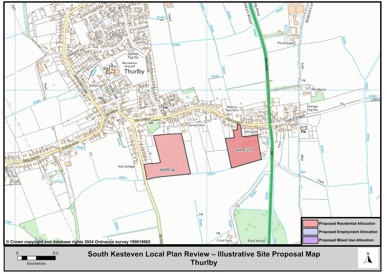
Figure 40: Thurlby Illustrative Map