South Kesteven Design Code Draft
Chapter 3. Nature
Access to nature provably supports human health. Access to green spaces has demonstrable benefits for physical and mental wellbeing. It reduces stress reduction, improves air quality and encourages exercise. Thoughtful urban design that integrates natural environments can also support community resilience and neighbourliness.
3.1 Green Infrastructure
3.1.1 Introduction
Green infrastructure (GI) is the network of open space, woodlands, wildlife habitat, ponds, parks, street trees and sustainable urban drainage systems (SuDS) that pass through and link our towns and villages with clean air, water, and other natural resources. High quality green infrastructure increases biodiversity, maximise people’s exposure to greenery, provides amenity value and beauty, improves residents’ physical and mental health, reduces air and water pollution and minimises flood risk.
3.1.2 Responding to the landscape
Development should work with and respond to the characteristics of the site including existing levels, topography and landscape features such as watercourses, hedgerows, trees, orchards and woodland, street patterns, field/plot patterns, buildings and landmarks. This will help developments 'nestle' in the landscape and reduce the need for site reprofiling and retaining walls.
How this has been achieved should be explained in the site and context analysis detailed in Chapter 2.
3.1.2.01
Developments should take account of views towards the site, particularly from public areas such as Public Rights of Way (PROWs) and rural streets, by the use of high-quality buildings, abundant trees and/or trees and landscaping.
3.1.2.02
Along development boundaries, appropriate green infrastructure that is in keeping with the local landscape character, such as hedgerows, trees, and informal open spaces should be used to soften the urban–rural boundary.
3.1.2.03
Views both into and out of the site to prominent natural features could be maintained and open spaces could be located to celebrate these views.
3.1.3 Enjoying nature
3.1.3.01
Public Rights of Way (PROW) and statutory bridleways should be: a) retained on their current alignment; b) linked into existing and new footway networks; c) retain an open aspect and green landscape character (such as within a public green space) and d) only be diverted with robust justification and being as close as possible to their original alignment.
N1: All development proposals must integrate well designed green blue infrastructure within and throughout layouts and scheme designs, creating a green character that enhances biodiversity, responds to the landscape character and context and brings people closer to nature. A landscape strategy must be submitted to the Council early in the design process, proportionate to the scale of development, illustrating and describing the a) response to context, b) character, c) function and d) biodiversity of all green blue infrastructure components of the site.
3.2 Biodiversity
3.2.1 A home for nature
3.2.1.01
Existing healthy and well-formed trees should be retained and any removal must be robuslty justified with, for example, an arboricultural assessment (e.g. to achieve a site access where no other locations exist). Layouts should be designed around retained trees (e.g. included within a feature space). The response to the retained tree/s should be proportionate to size, species and place making potential (see also Local Plan Policy EN2).
3.2.1.02
Large developments (50 homes or more) should include a linear park running through or around the entirety of the site or include parks connected by green blue routes as navigational aids, to provide pleasant and practical routes for pedestrians and cyclists and to function as wildlife corridors.
3.3 Green Infrastructure
3.3.1 Enjoying nature
3.3.1.01
Layouts should be configured to ensure that green routes create loops and are not exclusively linear, encouraging people to take leisure walks. Outward facing layouts that front perimeter hedgerows often enable these attractive green routes.
3.3.1.02
Longer green circuits could be signposted at 1km intervals.
3.3.1.03
3.3.1.04
3.4 Biodiversity
3.4.1 A home for nature
3.4.1.01
New developments should not pose a threat to designated nature conservation sites, including statutory sites and non-statutory sites.

As well as protecting existing biodiversity and assisting with biodiversity net gain (BNG) targets, established trees are beautiful natural features that will enhance new developments.
3.4.1.02
Where hedgerows are retained, they should be given space, enhanced if necessary and incorporated meaningfully within green spaces. They will not be adopted by LCC. Hedgerows or other planting in front of homes reflect a rural character and existing hedgerows have more protection if within the public realm rather than backed onto by rear gardens.
3.4.2 Trees and planting
Street trees are an invaluable means of creating greener, safer, healthier and more resilient streets. This section covers planting principles for creating greener streets in new developments and retrofit schemes to regreen existing urban streets. This is in line with the recommendations of the England Tree Action Plan (DEFRA), the NPPF, the Building Better Building Beautiful Commission (BBBBC) and the National Model Design Code (NMDC).
Reasons to include street trees:
- Improve air quality, absorb pollution and create a physical barrier from road pollution;
- Shade streets, help regulate temperature and reduce the urban heat island effect;
- Enhance biodiversity and ecological connectivity, creating habitat for wildlife;
- Intercept rainfall and increase infiltration, reducing pressure on drainage systems and recharging aquifers;
- Assist with traffic calming and speed control;
- Encourage physical activity, walking and cycling;
- Improve mental wellbeing and cognitive development;
- Enhance the appearance of streets, setting of buildings and help define public realm; and
- Increase property values.
Trees must be planted in line with Lincolnshire County Council guidelines.
3.4.2.02
3.4.2.03
A tree strategy should be provided, describing and illustrating how existing and new trees will enhance the character of the site and what their function will be (for example, how they create streets and spaces with different characters and where large species might be located to create landmarks). A tree strategy could form part of a landscape strategy as required in N1.
A list of suitable species can be found in the Appendix.
3.4.2.04
3.4.3 Wildlife
3.4.3.01
3.4.3.02
3.5 Blue infrastructure
3.5.1 Introduction
Blue infrastructure refers to water-based natural and engineered systems which are integrated into the urban environment. It aims to manage water sustainably, enhance biodiversity, mitigate flooding, and improve the quality of life in cities.
3.5.2 Sustainable drainage (SuDS)
SuDS are designed to mimic natural drainage systems and are more resilient and cost effective than conventional drainage methods. Lincolnshire is at increasing risk of water stress, rising temperatures and flooding. Sustainable water management plays an essential role in alleviating these risks as well as helping meet wider climate resilience aims. SuDS also help placemaking strategies and deliver wider benefits.
SuDS are designed around the following four 'pillars':
- Water quantity: controlling the rate and volume of runoff, preserve the water cycle and reduce flood risk.
- Amenity: creating and sustaining better places for people, through the introduction of greenery and water features.
- Water quality: managing the quality of runoff and prevent pollution of watercourses.
- Biodiversity: creating and sustaining better places for nature by including planting and habitat niches that respond to surrounding ecological conditions.
3.5.3 SuDS Design Principles
Specific designs will differ by location and will reflect the local context, site layout, local topography and geology. Appropriate SuDS solutions will vary across South Kesteven, particularly in the low lying Fenland areas to the east.
Detailed SuDS design guidance is available from Lincolnshire County Council here.
3.5.3.02
3.5.3.03
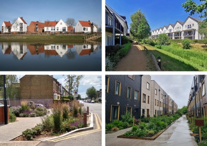

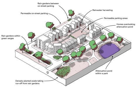
3.5.4 SuDS Components
A variety of SuDS components can be used, and solutions will depend on the site layout and context. Detailed design guidance on these elements can be found in the CIRIA SuDS Manual and Lincolnshire County Council Guidance.
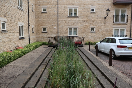
The following SuDS features will be permitted in streets and public spaces:
- Rain gardens: Shallow planting designed to capture water runoff in urban areas.
- Roadsisde swales, swales and channels: Landscaped channels which direct excess rainwater, including hard landscaped rills and canals.
- Infiltration systems: Features such as soakaways that allow water to infiltrate back into the ground.
- Permeable paving: Porous surfacing materials with an engineered sub base to store water.
- Attenuation ponds: With a permanent volume of water, providing additional biodiversity. These can provide site scale attenuation volumes, or small ponds can be integrated into the site to provide source control.
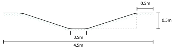
- Detention basins: Recessed landscaped areas, these temporarily store excess rainwater before slowly releasing into the drainage network or the ground.
3.5.4.01
3.5.4.02
Attenuation poinds should be well overlooked by home frontages.
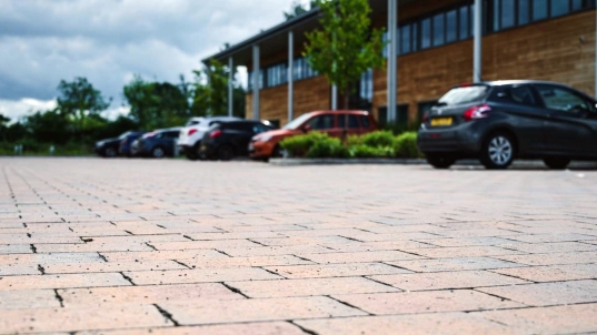
3.5.5 Permeable paving
Permeable paving is a space efficient SuDS solution that works well in high density developments, and will be adopted by Lincolnshire County Council.
3.5.5.01
3.5.5.02
3.5.5.03
3.5.5.04
- Pavements
- Off street walking routes
- Carriageways in local and tertiary streets
- On street parking spaces.
3.5.5.05