Proposed Housing and Mixed-Use Site Allocations
Grantham View responses
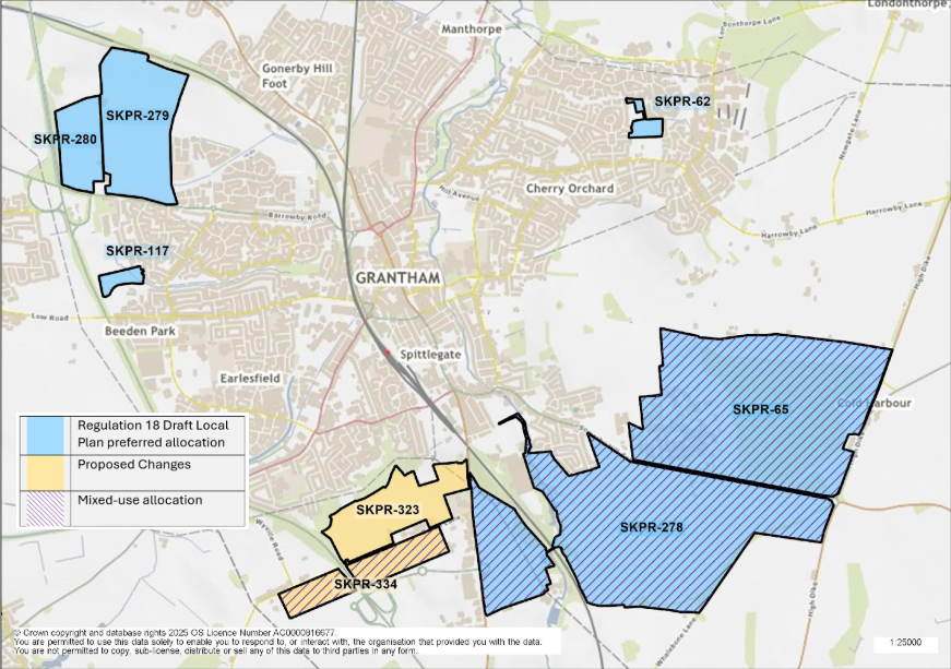
Figure 3: This map shows the town of Grantham and highlights eight site allocations. SKPR-280, SKPR-279, SKPR-117, and SKPR-62 were identified as preferred housing allocations in the Regulation 18 Draft Local Plan. SKPR-65 and SKPR-278 were identified as preferred mixed-use site allocations in the Regulation 18 Draft Local Plan. SKPR-323 is proposed as a new housing allocation and SKPR-334 is proposed as a new mixed use housing allocation.
SKPR-278 (GR3-H1): Spitalgate Heath - Garden Village (Mixed Use Allocation) View responses
Indicative Unit Numbers: 3700 (1,512 anticipated to be constructed by 2043)
Approximate Density: 30 Dwellings per hectare.
Planning permission will be granted for the creation of a Garden Village at Spitalgate Heath. The development must ensure that the following principles are met:
- To ensure the comprehensive development of the entire allocation, incremental full applications will not be acceptable. An outline or hybrid application will be required for the entire site. This must be accompanied by a detailed masterplan.
- The site must be planned and developed on the basis of current Garden Village principles and national best practice.
- The overall design of the Garden Village must provide a model for sustainable living with exemplary standard of design, construction and community facilities. The design and layout must foster and support a sense of community. To ensure the development achieves good, high quality design, a design code must be prepared for the site.
- The development must include new employment generating areas of approximately 110,000 m2 including class E, B2 and B8 uses.
- The development must make provision for safe and convenient highways, footway and cycleway connections throughout the site connecting it to local schools, community facilities, linking it to Grantham, the Prince William of Gloucester Barracks allocated site and the wider countryside.
- The layout of the development must provide appropriate transport infrastructure measures to encourage walking, cycling and use of public transport in order to maximise opportunities for sustainable modes of transport and encourage active travel. This must include an Active Travel route from the site to Grantham town centre and railway station.
- The development must incorporate Sustainable Drainage Systems, except where it can be demonstrated that it is not practical or possible to do so.
- The masterplanning and development of the site must have careful regard to landscape and topography and reflect its location within the Witham Valley.
- The potential for the development to impact on the townscape and heritage assets including views out of the site must be considered and reflected in the masterplanning of this site.
- The development must provide net gains in biodiversity on site and contribute to wider ecological networks where possible. This site is within or includes an area of Biodiversity Opportunity. Proposals on this site should incorporate the relevant principles for development within Biodiversity Opportunity Areas set out in New Policy 4: Biodiversity Opportunity and Delivering Measurable Net Gains.
- This site is within or includes a Green Infrastructure Area. Proposals on this site should incorporate the relevant principles for development within Green Infrastructure Areas set out in Policy EN3 Green Infrastructure.
- The development must seek to improve biodiversity and avoid, or minimise, impacts on Woodnook Valley SSSI and the adjacent and nearby Local Wildlife Sites.
- Additional treatment capacity is required at waste water treatment works and new discharge permits are required for water quality targets. This should be incorporated early on in the development of scheme specifics, as part of a scheme wide delivery strategy which demonstrates that capacity is available or could be made available to serve the development subject to phasing.
- The development must include on-site renewable energy provision and demonstrate how it will be resilient to future climate change.
- The development must provide a village hub with community facilities, including a community centre and shops to serve the day today needs of future residents and create a community destination to support a sense of community.
- The development must provide an appropriate mix of housing types, affordability and tenures for all stage of life to meet housing needs.
- The development must provide primary and secondary schools on site, as required.
- The development must provide blue green infrastructure throughout the site including multifunctional green spaces, high quality open space, a Riverside Park, including a pedestrian link into Grantham accessible opportunities for recreation through the provision of open space and private gardens, green access routes and allotments.
- The development must make provision for the long term stewardship of the site, demonstrating how this will be secured to support the new community and to ensure the creation of a flourishing and vibrant place where people want to live and work in the future.
- The development must contribute towards the delivery of the Grantham Southern Relief Road which facilitates this development and must contribute towards or deliver other offsite highways mitigation as identified through a site-specific Transport Assessment
- This site is situated within a Minerals Safeguarding Area. A Minerals Assessment will be required to accompany any planning application for the subject.
Summary of Proposed Changes
The policy has been reviewed to include reference to:
- an active travel route from the site into Grantham and the railway station;
- Its location within the Witham Valley;
- a pedestrian link into Grantham; and
- the requirement for the site to contribute towards or deliver other offsite highways mitigation as identified through a site-specific Transport Assessment
SKPR-279 (GR3-H2): Rectory Farm (Phase 2) View responses
Indicative Unit Numbers: 1150
Approximate Density: 30 Dwellings per hectare
Development of Rectory Farm (Phase 2)must be planned for in a comprehensive manner such that each of the three phases (and corresponding landowners/developers/site promoter(s)) work together to provide a single urban extension.
The Council will work with the site promoter(s) / landowners / developers to ensure that a planning application / master planning strategy is developed that enables planning applications for the site to be progressed without compromising the delivery of the whole site comprehensively. Any application must accord with the Rectory Farm Supplementary Planning Document adopted November 2021.
Applications that fail to demonstrate how they relate and connect to the wider site, including, where relevant, connections to the neighbouring Poplar Farm development will be resisted.
The following development principles accompany this allocation:
- Development should provide a strategic access solution which limits the number of new access points onto the A52 Barrowby Road. The strategic access solution should include details on vehicular, pedestrian and cycleway connections to the adjacent Poplar Farm.
- The layout of the development should provide appropriate transport infrastructure measures to encourage walking, cycling and use of public transport in order to maximise opportunities for sustainable modes of transport.
- Provide for safe and convenient highway, footway, and cycleway connections throughout the site connecting residents to local schools, including the new Poplar Farm Primary School, community facilities and into the town centre.
- The development will make suitable open space provision including providing an additional playing field or land for such use, adjacent to the boundary of Poplar Farm School.
- Land in the North-West corner of the site, following the public footpath known as Barr 11/4, shall be used for the provision of landscaping and open space only, to protect the sensitive landscape from development.
- The development should incorporate Sustainable Urban Drainage systems where practical and possible to do so.
- The development should provide net gains in biodiversity on site and contribute to wider ecological networks where possible. This site is within or includes an area of Biodiversity Opportunity. Proposals on this site should incorporate the relevant principles for development within Biodiversity Opportunity Areas set out in New Policy 4: Biodiversity Opportunity and Delivering Measurable Net Gains.
- This site is within or includes a Green Infrastructure Area. Proposals on this site should incorporate the relevant principles for development within Green Infrastructure Areas set out in Policy EN3 Green Infrastructure.
- Development of this site should seek to positively incorporate strategic views towards the Town's heritage assets and their setting (i.e. Belmount Tower, St Wulfram's, and St Sebastian's). The topography of the site shall be carefully considered to ensure that development proposals minimise possible harm to cross town views of these heritage features.
- Additional treatment capacity is required at waste water treatment works and new discharge permits are required for water quality targets. This should be incorporated early on in the development of scheme specifics as part of a scheme wide delivery strategy which demonstrates that capacity is available or could be made available to serve the development subject to phasing.
- To ensure the development achieves good, high quality design a design code will be prepared for the whole site.
- Detailed proposals should come forward comprehensively to reflect the Development Brief for this site.
- The development will provide appropriate mitigation measures to the Strategic Road Network if required and demonstrated by relevant transport assessment and agreed with National Highways.
Summary of Proposed Changes
Reference to Highways England has been updated, as it is now known as National Highways.
SKPR-280 (GR3-H3): Rectory Farm (Phase 3) View responses
Indicative Unit Numbers: 404
Assumed Density: 30 Dwellings per hectare
The following development principles accompany this allocation:
- A comprehensive masterplan will be prepared for this site, which clearly sets out an appropriate relationship with the adjacent Rectory Farm site/s (Phase 2). Detailed proposals should come forward comprehensively to reflect the Development Brief for this site.
- In masterplanning the site, consideration should be given to providing vehicular, pedestrian and cycleway connections into the site from the adjacent Rectory Farm development (Phase 2).
- The layout of the development should provide appropriate transport infrastructure measures to encourage walking, cycling and use of public transport in order to maximise opportunities for sustainable modes of transport.
- Provide safe and convenient highway, footway, and cycleway connections throughout the site connecting it to local schools, community facilities and into the wider town.
- The development should incorporate Sustainable Urban Drainage systems where practical and possible to do so.
- The development should provide net gains in biodiversity on site and contribute to wider ecological networks where possible. This site is within or includes an area of Biodiversity Opportunity. Proposals on this site should incorporate the relevant principles for development within Biodiversity Opportunity Areas set out in New Policy 4: Biodiversity Opportunity and Delivering Measurable Net Gains.
- This site is within or includes a Green Infrastructure Area. Proposals on this site should incorporate the relevant principles for development within Green Infrastructure Areas set out in Policy EN3 Green Infrastructure.
- The northern edge of the site shall not extend any further north than as shown on the policies map; this is to prevent possible impact on heritage features, their settings and the landscape.
- Noise mitigation measures shall be proactively incorporated in the development.
- Sensitive landscaping treatments shall be provided along the northern edge of the site.
- Additional treatment capacity is required at waste water treatment works and new discharge permits are required for water quality targets. This should be incorporated early on in the development of scheme specifics as part of a scheme wide delivery strategy which demonstrates that capacity is available or could be made available to serve the development subject to phasing.
- To ensure the development achieves good, high quality design a design code will be prepared for the site.
- The development will provide appropriate mitigation measures to the Strategic Road Network if required and demonstrated by relevant transport assessment and agreed with National Highways.
Summary of Proposed Changes
Reference to Highways England has been updated, as it is now known as National Highways.
SKPR-65 (GR3-H4): Prince William of Gloucester Barracks (Mixed Use Allocation) View responses
Indicative Unit Numbers up to 3,000 (approx. 1,890 anticipated to be constructed by 2043) including employment generating area of 8ha.
Planning permission will be granted for the creation of a new settlement based on garden village principles, with a minimum of 3,000 dwellings on the site of the Prince William of Gloucester Barracks. Any scope to increase site capacity beyond 4,000 dwellings would need to be subject to more detailed evidence and design work being undertaken.
The new community should be developed as a comprehensive mixed-use scheme and should be developed in accordance with a comprehensive masterplan prepared for the whole site, which the Council will be consulted on prior to the submission of a planning application.
The proposed development will comprise new homes together with employment generating uses, local services and community uses, extensive open space provision and substantial tree planting. The development must ensure that the following key elements are provided:
- The development must include a new employment generating area of 8ha located to optimise access to the A52 in order to support the development of a sustainable new community; which includes class E, B2 and B8 uses.
- highway infrastructure to access the site and to ensure impact on the existing highway network is minimised, including the provision of any appropriate mitigation to the strategic highway network, if required and demonstrated by relevant transport assessment, and agreed with National Highways.
- a demonstrable design logic that fosters and supports a sense of community;
- provision of new primary school and additional secondary school places as required;
- an appropriate mix of housing types, affordability and tenures to meet housing needs, for all stages of life;
- a village hub with local neighbourhood shops to serve the everyday needs of residents and create a community destination to support a sense of community;
- new blue green infrastructure incorporating networks of multifunctional green spaces; high quality open space; accessible opportunities for recreation through the provision of open space and private gardens; and the feasible retention of as much existing woodland as possible including recently planted areas, as well as the provision of new areas of woodland and green access routes;
- Landscape buffers/green infrastructure to be provided to the north of the site.
- safe and convenient highway, footway, and cycleway connections throughout the site connecting it to local schools, community facilities and linking to Grantham, Spitalgate Heath Garden Village and the wider countryside;
- appropriate surface water management including Sustainable Urban Drainage systems wherever practical;
- the establishment of appropriate liaison and governance solution identifying the ways in which long term stewardship can be secured to support the new community and to ensure the creation of a flourishing and vibrant place where people want to live and work in the future; and
- consideration of the scope to increase site capacity beyond 4,000 dwellings subject to more detailed evidence and design work being undertaken.
- The development must seek to improve biodiversity and avoid, or minimise, impacts on Woodnook Valley SSSI and the adjacent and nearby Local Wildlife Sites.
- This site is within or includes an area of Biodiversity Opportunity. Proposals on this site should incorporate the relevant principles for development within Biodiversity Opportunity Areas set out in New Policy 4: Biodiversity Opportunity and Delivering Measurable Net Gains.
- This site is within or includes a Green Infrastructure Area. Proposals on this site should incorporate the relevant principles for development within Green Infrastructure Areas set out in Policy EN3 Green Infrastructure.
For the purposes of any forthcoming planning applications, the Masterplan for the
development will determine the capacity for the site and should therefore be supported by the following evidence:
- a comprehensive Travel Plan to maximise integrated transport choice and connections to services and facilities in neighbouring settlements. These could include; appropriate access arrangements and a network of dedicated pedestrian and cycle links throughout the new settlement with direct and clearly defined connections to neighbouring settlements and appropriate infrastructure to facilitate the use of electric vehicles;
- of how development will avoid, minimise and where necessary mitigate or compensate any adverse environmental impact, enhance the landscape and provide green infrastructure to support the creation of new habitat and an overall increase in biodiversity across the whole site;
- of the most appropriate means of managing waste water and surface water that meets the requirements of the Water Framework Directive and secures improvements in water quality and surface water management;
- a comprehensive heritage impact assessment to demonstrate how development will avoid, minimise and enhance or compensate any adverse effect on designated and non-designated heritage assets including Belton House and Registered Park and Garden incorporating an integrated assessment of their significance and related setting. The proposal must take into account the Belton House Park Setting Study and Policy GR1;
- that the new settlement will be developed within a set of high quality design principles concerning the use of appropriate styles and materials and incorporates sustainably designed "future proof" homes and workplaces; and
- The site is situated within a Mineral Safeguarding Area. A Minerals Assessment will be required to accompany any planning application for the site.
Summary of Proposed Changes
- Indicative number of dwellings for the site has been reduced from 4,000 to 3,000 due to Biodiversity Net Gain requirements.
- Employment land criterion has been strengthened
- Criterion inserted requiring landscape buffers/green infrastructure to be provided to the north of the site.
- Criterion inserted requiring development to seek to improve biodiversity and avoid, or minimise, impacts on Woodnook Valley SSSI and the adjacent and nearby Local Wildlife Sites.
- Heritage criterion has been strengthened to include reference to Belton House and Registered Park and Garden
- Reference to Highways England has been updated, as it is now known as National Highways.
SKPR-117 – Land to the East of Sheepwash Lane View responses
Indicative Unit Numbers: 84
Assumed Density: 35 Dwellings per hectare
The following development principles accompany this allocation:
- Highway, footway, cycleway connections should be provided throughout the site which connect the site into the wider town and into the existing developments to the north and south of the site, where possible.
- A public right of way runs along the western edge of the site, this should be retained and connections incorporated into the development, where possible.
- Suitable boundary treatment and noise attenuation should be provided along the A1 edge of the site.
- The development proposal should ensure the integration of the open space to the north of the site and incorporate the Barrowby stream as a positive landscape feature.
- Any contaminated land should be remediated to recognised standards.
- This site is within or includes a Green Infrastructure Area. Proposals on this site should incorporate the relevant principles for development within Green Infrastructure Areas set out in Policy EN3 Green Infrastructure.
Summary of Proposed Changes
Indicative units and assumed density have been updated in line with the Housing Density Study
SKPR-62 – The Grantham Church High School Playing Fields, Queensway View responses
Indicative Unit Numbers: 88
Assumed Density: 35 Dwellings per hectare
The following development principles accompany this allocation:
- Highway, footway, cycleway connections should be provided throughout the site which connect the site into the wider town and into the existing approved development surrounding the site, where possible.
- Connections to integrate the approved scheme towards the green lane cycle network to the north of the site should be made.
- Footway connections should be made from the recreational ground to the south of the site into the development.
- The development proposal should include an appropriate mix of housing types for the area to ensure a mixed and balanced community.
- This site is within or includes a Green Infrastructure Area. Proposals on this site should incorporate the relevant principles for development within Green Infrastructure Areas set out in Policy EN3 Green Infrastructure.
Summary of Proposed Changes
Indicative units and assumed density have been updated in line with the Housing Density Study.
SKPR-323 Land north of Gorse Lane, Grantham View responses
Indicative Unit Numbers: 874
Assumed Density: 35 dwellings per hectare
The following development principles accompany this allocation:
- A comprehensive masterplan, supported by an agreed phasing plan, which clearly sets out an appropriate relationship with the adjacent Gorse Lane allocation (south), is required for the entire site.
- Connections required to the north through upgrade of the existing cycle and footpath onto Denton Avenue.
- Connection and improvements to the Public Right of Way network.
- Noise Assessment required as part of any planning application.
- Site levels will need to be carefully considered and SuDS details will need to be part of the masterplan.
- Transport Assessment, Travel Plan and a Construction Management Plan required
- Connections to SHGV to the east will be important for local services
- Pro-rata contribution to be provided for the upgrade of Gorse Lane.
- Spittlegate Farm and Heath Farm converted buildings are non-designated heritage assets, the setting of the buildings to be considered through a Heritage Impact Assessment.
- Pre-commencement archaeological interventions and Heritage Impact Assessment required.
Summary of Proposed Changes
SKPR-323 Land north of Gorse Lane, Grantham is proposed as a new site allocation to meet the minimum housing requirement for South Kesteven over the plan period.
SKPR-334 (SKPR–189, SKPR-263, SKPR 310, SKPR 313) Land south of Gorse Lane, Grantham (mixed use) View responses
Indicative Unit Numbers: 530 dwellings (assumed density 35 dwellings per hectare, 2 hectares for permanent Gypsy and Travellers and Travelling Showpeople pitch/plot provision.
The following development principles accompany this allocation:
- The development proposal must make provision for 2ha of land to the west of the A1, accommodating at least 20 permanent pitches/plots, to meet identified accommodation needs of Gypsies,Travellers and Travelling Showpeople, as per the February 2024 Accommodation Assessment.
- A comprehensive masterplan, supported by an agreed phasing plan to include the delivery of land for Gypsy and Traveller accommodation within the first phase.
- Masterplan to include an appropriate relationship with the adjacent Gorse Lane allocation (north) and employment land allocations to the south.
- Pedestrian facilities on Gorse Lane required, including consideration of the narrow bridge which crosses the A1.
- This site is within or includes a Green Infrastructure Opportunity Area. Proposals on this site should incorporate the relevant principles for development within Green Infrastructure Areas set out in Policy EN3 Green Infrastructure.
- Spittlegate Farm and Heath Farm converted buildings are non-designated heritage assets, the setting of the buildings to be considered through a Heritage Impact Assessment.
- Noise assessment required, with consideration of the impact of the A1. Noise Assessment conclusions to be taken into account when masterplanning the location of residential and Gypsy & Traveller accommodation uses.
- Pre-commencement archaeological investigations required.
- Include appropriate open space/green infrastructure, including allotments.
- Suitable boundary treatment and noise attenuation should be provided along the A1 edge of the site to protect the amenity of future occupiers.
- Screening to be provided to the south of the development.