Proposed Housing and Mixed-Use Site Allocations
Bourne View responses
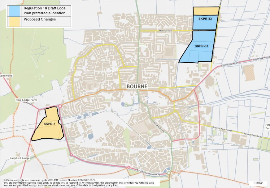
Figure 5: This map shows the town of Bourne and highlights three site allocations. SKPR-53 and SKPR-83 were identified as preferred housing allocations in the Regulation 18 Draft Local Plan, the land to the north of SKPR-83 has been included as a proposed change. SKPR-7 is proposed as a new housing allocation.
SKPR-53 – Land at Mill Drove View responses
Indicative Unit Numbers: 441
Assumed Density: 35 Dwellings per hectare
The following development principles accompany this allocation:
- A comprehensive masterplan is required for the site. All parties shall work together to bring forward a comprehensive plan for the site, including the phasing of development.
- A maximum of 3ha of land, adjacent to Bourne Academy to be as playing field provision for the school.
- Highway, footway, cycleway connections should be provided throughout the site to the wider town and SKPR-83 – Land North of Mill Drove.
- Development should integrate the public right of way along the Carr Dyke into the pedestrian movements throughout and into the site.
- The development proposal should ensure the integration of Carr Dyke as a positive landscape feature and provision of open space and ensure that the requisite easement of the Carr Dyke is provided to allow maintenance of the water feature.
- Landscape screening to the eastern edge of the site will be required to reduce the impact on views into the site from the open countryside.
- The high flood risk area within the centre of the site should not be developed but utilised for open space provision, landscaping and sustainable urban drainage (SUDS), as necessary.
- Screening to the south of the development will be required to minimise conflict with the existing industrial development.
- There is the potential for archaeological remains on this site and the appropriate pre-commencement investigations should be carried out.
Summary of Proposed Changes
Indicative units and assumed density have been updated in line with the Housing Density Study
Reference to Green Infrastructure Area removed as site not within a Green Infrastructure Area, however proposal will need to take into account Policy EN3: Green Infrastructure which seeks to protect and enhance Green Infrastructure across the district.
Policy has been amended to include reference to the potential archaeological remains on site.
SKPR-83 – Land North of Mill Drove View responses
Indicative Unit Numbers: 326
Assumed Density: 35 Dwellings per hectare
The following development principles accompany this allocation:
- A comprehensive masterplan is required for the site.
- Highway, footway, cycleway connections should be provided throughout the site to the wider town and SKPR-53 – Land at Mill Drove .
- Car Dyke Scheduled Monument is located to the north of the site. Heritage Impact Assessment required, and pre-commencement investigations should be carried out due to potential for archaeological remains on the site.
- Development should integrate the public right of way along the Car Dyke into the pedestrian movements throughout and into the site.
- The development proposal should ensure the integration of Car Dyke as a positive landscape feature and provision of open space and ensure that the requisite easement of the Carr Dyke is provided to allow maintenance of the water feature.
- Landscape screening to the northern and eastern edges of the site will be required to reduce the impact on views into the site from the open countryside.
- Development to the north must not extend past the existing built development line to the west. Residual land to be utilised for open space provision, landscaping and sustainable urban drainage (SUDS), as necessary.
- This site is within or includes an area of Biodiversity Opportunity. Proposals on this site should incorporate the relevant principles for development within Biodiversity Opportunity Areas set out in New Policy 4: Biodiversity Opportunity and Delivering Measurable Net Gains.
- This site is within or includes a Green Infrastructure Area. Proposals on this site should incorporate the relevant principles for development within Green Infrastructure Areas set out in Policy EN3 Green Infrastructure.
Summary of Proposed Changes
Indicative units and assumed density have been updated in line with the Housing Density Study
The land to the north of the site as submitted has been included as part of the allocation, the policy criteria includes reference that this area should be utilised for open space provision, landscaping and sustainable urban drainage.
Policy amended to include criteria requiring a Heritage Impact Assessment and reference to the Car Dyke Scheduled Monument. Reference to the potential archaeological remains on site.
SKPR-7 Land to the south west of Raymond Mays Way View responses
Indicative Unit Numbers: 270
Assumed Density: 30 Dwellings per hectare
The following development principles accompany this allocation:
- A comprehensive masterplan is required for the site.
- Pedestrian links, such as footway and cycleway connections into the town from the site should be incorporated in the development proposal.
- Pedestrian and cycle connections into Bourne along West Road improvements to be provided.
- A Transport Assessment is required.
- Pre-commencement investigations should be carried out due to potential for archaeological remains on the site.
- The development must seek to avoid impacts on Local Wildlife Site, Toft Tunnel.
- This site is within or includes an area of Biodiversity Opportunity. Proposals on this site should incorporate the relevant principles for development within Biodiversity Opportunity Areas set out in New Policy 4: Biodiversity Opportunity and Delivering Measurable Net Gains.