Proposed Housing and Mixed-Use Site Allocations
3. Proposed Changes to the Housing and Mixed-Use Site Allocations Proposed through the 2024 Regulation 18 Draft Local Plan
Removal of proposed allocations
3.1 Following the Draft Local Plan consultation (2024), the housing sites which will not form part of the Regulation 19 Pre-Submission Local Plan are set out below. We are not seeking any further comments on these sites as part of this consultation.
Table 3: Removal of proposed allocations
|
Policy Code |
Settlement |
Location |
Indicative number of dwellings |
Reasoning for not taking forward allocation |
|
SKPR-268 |
Grantham |
Station Approach (mixed-use) |
268 |
Concerns regarding site deliverability |
|
SKPR-57 |
Grantham |
Belton Lane |
628 |
Significant impact on highways |
|
SKPR-144 |
The Deepings |
Millfield Road, Market Deeping |
200 |
Proposed land allocations are focused to the east of the Deepings |
|
SKPR-74 |
Harlaxton |
Land West of The Drift |
24 |
Full planning permission has been granted |
Amendments to site capacity
3.2 Some proposed allocations from the Draft Local Plan consultation have been expanded in size by including adjacent land submissions. Site policy codes in the previous consultation may have changed but the original site submission references as previously consulted on have been included in this consultation for clarity.
3.3 Additionally, as recommended by the Housing Density Study (2025), indicative site densities of some allocations in the four main towns, Grantham, Stamford, Bourne, and The Deepings have increased.
Table 4: Amendments to site capacity
|
Policy Code |
Settlement |
Location |
Site Area (Hectares) |
Indicative number of dwellings |
|
SKPR-266 |
Stamford |
Stamford Gateway (Exeter Fields) (mixed-use) |
10 |
Decrease from 180 to 105 dwellings, and 5ha of employment land |
|
SKPR-65 |
Grantham |
Prince William of Gloucester Barracks (mixed-use) (GR3-H4) |
184 |
Decrease from 4000 to 3000 dwellings, and 8 ha of employment land |
|
SKPR-117 |
Grantham |
Land to the East of Sheepwash Lane |
4 |
Increase from 72 to 84 |
|
SKPR-62 |
Grantham |
The Grantham Church (VA) High School Playing Fields, Queensway |
4.2 |
Increase from 76 to 88 |
|
SKPR-53 |
Bourne |
Land at Mill Drove, PE6 9PB |
21 |
Increase from 285 to 441 |
|
SKPR-83 |
Bourne |
Land north of Mill Drove, Bourne |
Increase from 9.54 to 15.5 |
Increase from 172 to 326 |
|
SKPR-307 (SKPR-26) |
The Deepings |
Priory Farm Land, Deeping St James |
Increase from 0.77 to 9.2ha |
Increase from 18 to 193 |
|
SKPR-283 |
Ancaster |
Land off St Martins Way, Ancaster |
2.6 |
Decrease from 65 to 62 |
|
SKPR-319 (SKPR-109 and SKPR-110) |
Baston |
Land fronting Deeping Road (A15) and King Street |
Increase from 4.8 to 15.7 |
Increase from 86 to 283 |
|
SKPR-317 (SKPR-61 and SKPR-103) |
Billingborough |
Land to the west of Pointon Road and site of former Aveland School |
7.2 |
Decrease from 140 to 130 |
|
SKPR-309 (SKPR-120 and SKPR-232) |
Colsterworth |
Land at the East of Stamford Road, Colsterworth |
Increase from 3.9 to 17.2 |
Increase from 70 to 310 |
Additional proposed allocations
3.4 Additional housing allocations have been identified across the district to meet the increased housing need.
Table 5: Additional proposed allocations
|
Policy Code |
Settlement |
Location |
Site Area (Hectares) |
Indicative number of dwellings |
|
SKPR-330 |
The Deepings |
Land east of Linchfield Road |
40 |
840 |
|
SKPR-55 |
The Deepings |
Towngate east |
3.7 |
104 |
|
SKPR-323 |
Grantham |
Land north of Gorse Lane |
41.6 |
874 |
|
SKPR-334 (SKPR–189, SKPR-263, SKPR 310, SKPR 313) |
Grantham |
Land south of Gorse Lane (mixed-use) |
27.2 |
530 dwellings and 2ha of land for Gypsy & Traveller accommodation (approximately 20 pitches) |
|
SKPR-7 |
Bourne |
Land to the south west of Raymond Mays Way |
17.3 |
270 |
|
SKPR-168 |
Ancaster |
Land to the north of Wilsford Lane |
2.4 |
58 |
|
SKPR-327 |
Barrowby |
Land to east of The Drift and land south of Low Road |
25.3 |
455 |
|
SKPR-322 |
Claypole |
Doddington Lane |
3.6 |
86 |
|
SKPR-233 |
Corby Glen |
Land fronting Bourne Road and Swinstead Road |
16.3 |
293 |
|
SKPR-318 |
Harlaxton |
Land to west of The Drift |
6.2 |
112 |
No proposed changes
3.5 The following proposed housing allocations remain unchanged. However, some policy criteria may have been updated in response to comments received during the Draft Local Plan consultation. We are seeking your views on any of these changes.
Table 6: No proposed changes to allocations
|
Policy Code |
Settlement |
Location |
Site Area (Hectares) |
Indicative number of dwellings |
|
SKPR-281 |
Stamford |
STM1-H1: Stamford North |
53.03 |
1,350 |
|
SKPR-282 |
Stamford |
STM1-H2: Stamford East |
9.01 |
320 |
|
SKPR-278 |
Grantham |
Spitalgate Heath – Garden Village (mixed-use) (GR3-H1) |
215 |
3,700 dwellings and 11ha of employment land |
|
SKPR-279 |
Grantham |
Rectory Farm (Phase 2) (GR3-H2) |
61.05 |
1,150 |
|
SKPR-280 |
Grantham |
Rectory Farm (Phase 3) |
22.54 |
404 |
|
SKPR-36 |
The Deepings |
DEP1-H1 Towngate West |
3.12 |
73 |
|
SKPR-37 |
The Deepings |
DEP1-H2 Linchfield Road |
32.98 |
680 |
|
SKPR-58 |
Ancaster |
Land on the east side of Ermine Street |
0.9 |
26 |
|
SKPR-271 |
Ancaster |
LV-H2: Wilsford Lane (South) |
3.02 |
35 |
|
SKPR -242 |
Barkston |
Land East of Honington Road |
2.7 |
54 |
|
SKPR-272 |
Barrowby |
LV-H3: Low Road |
13.05 |
270 |
|
SKPR-247 |
Corby Glen |
Land North of Bourne Road |
8 |
144 |
|
SKPR-241 |
Great Gonerby |
Land off Church Lane |
3.6 |
86 |
|
SKPR-71 |
Langtoft |
Land north of Dickens Close, Stowe Road |
2.3 |
55 |
|
SKPR-273 |
Long Bennington |
LV-H7 Main Road (South) |
1.87 |
50 |
|
SKPR-135 |
Morton |
Land to the South of Edenham Road |
2 |
48 |
|
SKPR-274 |
Morton |
LV-H9: Folkingham Road |
4.61 |
71 |
|
SKPR-333 (SKPR-192 and SKPR-276) |
South Witham |
Land North of Mill Lane / High Street |
7.4 |
133 |
|
SKPR-275 |
South Witham |
LV-H10: Thistleton Lane and Mill Lane |
1.42 |
34 |
|
SKPR-56 |
Thurlby |
Land at Obthorpe Lane |
3.6 |
86 |
|
SKPR-277 |
Thurlby |
LV-H12: Part of Elm Farm Yard |
2.53 |
50 |
Existing and proposed housing supply
3.6 A breakdown of housing completions since the start of the plan period (2023), current commitments (full, reserved matters, and outline permission), and current adopted and proposed Local Plan allocations by settlement are set out in Table 7 below.
3.7 The total supply is based on the projected delivery of sites across the plan period up to 2043, as some sites are projected to be completed beyond the plan period. Please note that these figures will be reviewed and updated on a regular basis during the preparation of the Local Plan.
Table 7: Existing and proposed housing supply
|
Location |
Completions (2023/24) |
Existing Supply as at 31 April 2024* |
Adopted Local Plan housing land allocations |
Proposed Local Plan housing land allocations |
Total supply (based on delivery up to 2043) |
|
Grantham |
93 |
2,402 |
4,956 |
1,576 |
9,027 |
|
Stamford |
56 |
329 |
1,610 |
105 |
2,100 |
|
Bourne |
236 |
732 |
0 |
1,037 |
2,005 |
|
The Deepings |
24 |
173 |
753 |
1,137 |
2,087 |
|
Larger Villages |
137 |
670 |
461 |
2,421 |
3,689 |
|
Other Settlements |
29 |
735 |
0 |
0 |
764 |
|
Total |
575 |
5,041 |
7,780 |
6,276 |
19,672 |
*existing supply includes commitments, consents, council capital programmes, windfall allowance based on 30 dwellings per annum, (not including small site lapse rate).
3.8 Table 8 below sets out the percentage distribution based on completions, current commitments, adopted Local Plan allocations and windfall. This distribution is heavily influenced by the scale of allocations made in the adopted Local Plan.
Table 8: Housing distribution
|
Current percentage distribution of development |
|
|
Grantham |
46% |
|
Stamford |
11% |
|
Bourne |
9% |
|
The Deepings |
11% |
|
Larger Villages |
19% |
|
Other Settlements |
4% |
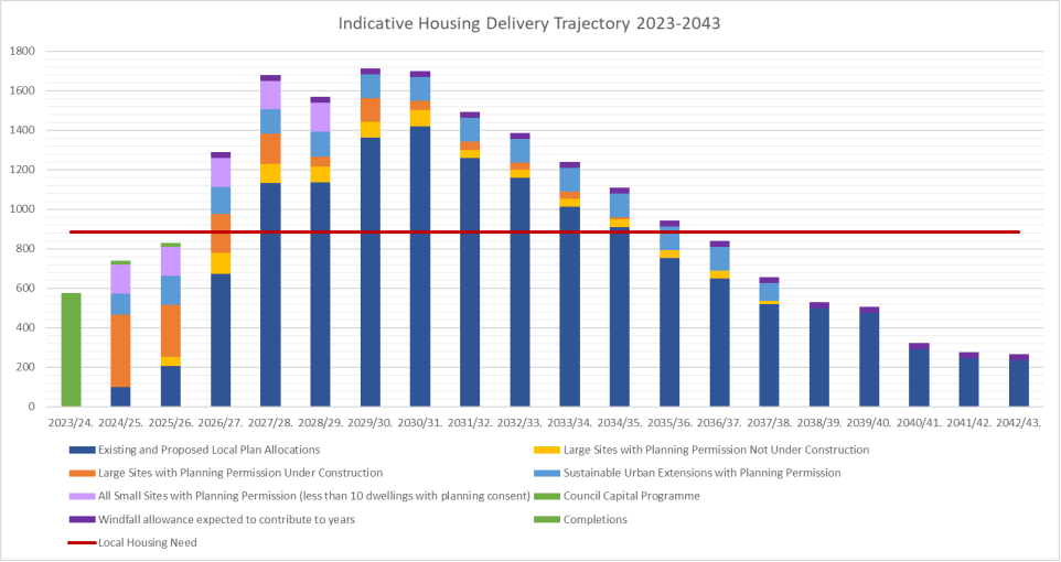
Figure 1: This chart shows the projected delivery of homes across the plan period (2023 – 2043).