Proposed Housing and Mixed-Use Site Allocations
Stamford View responses
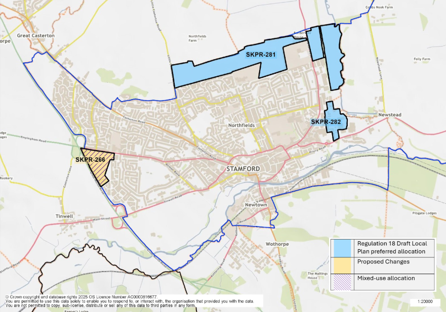
Figure 4: This map shows the town of Stamford and highlights three site allocations. SKPR-281 and SKPR-282 were identified as preferred housing allocations in the Regulation 18 Draft Local Plan. SKPR-266 is proposed as a new Mixed-Use site.
SKPR-281 (STM1-H1): Stamford North View responses
Indicative Unit Numbers: 1,350
Approximate Density: 30 Dwellings per hectare
The following development principles accompany this allocation:
- A high level masterplan, supported by a detailed development brief, appropriate full transport assessment and phasing plan, is required for the entire site (to include for the land extending into Quarry Farm, Rutland with an additional capacity of 650 dwellings).
- The layout of the development should provide appropriate transport infrastructure measures to encourage walking, cycling and use of public transport in order to maximise opportunities for sustainable modes of transport.
- Safe and convenient highway, footway, cycleway connections shall be provided throughout the site connecting it to local schools, community facilities and into the wider town.
- An East-West road to be provided through from Old Great North Road to Ryhall Road. This should offer mitigation to the town centre from the traffic generated as a result of this development.
- The development shall accommodate specialist housing needs through the provision of retirement housing, extra care or residential care housing.
- The development shall make provision for a new primary school.
- The development shall make provision for contributions towards the expansion or improvement of the adjacent secondary school.
- The development shall make provision for a local centre, to serve the needs of both existing and new residents to the area. The local centre should include the provision of appropriate social and community facilities.
- The development should positively respond to green infrastructure opportunities and provide sensitive landscaping to the northern edge of the site.
- Land to the east of the dismantled railway line should be utilised primarily for the provision of open space and strategic landscaping including surface water drainage features, only in order that the character of this area remains open and verdant.
- Flood Risk Assessment required, and where necessary, sequential approach to layout demonstrated
- The development should provide net gains in biodiversity on site and contribute to wider ecological networks where possible.
- The development will provide appropriate mitigation measures to the Strategic Road Network to be agreed with National Highways.
- This site is within or includes an area of Biodiversity Opportunity. Proposals on this site should incorporate the relevant principles for development within Biodiversity Opportunity Areas set out in New Policy 4: Biodiversity Opportunity and Delivering Measurable Net Gains.
- This site is within or includes a Green Infrastructure Area. Proposals on this site should incorporate the relevant principles for development within Green Infrastructure Areas set out in Policy EN3 Green Infrastructure.
Summary of Proposed Changes
Resolution to grant outline planning permission, subject to the completion of the S106 agreement.
Criterion added to include Flood Risk Assessment requirements.
Reference to Highways England has been updated, as it is now known as National Highways.
SKPR-282 (STM1- H2): Stamford East View responses
Indicative Unit Numbers: 320
Approximate Density: 30 Dwellings per hectare
The following development principles accompany this allocation:
- A comprehensive masterplan is required for the entire site.
- The layout of the development should provide appropriate transport infrastructure measures to encourage walking, cycling and use of public transport in order to maximise opportunities for sustainable modes of transport.
- This site represents a gateway location and this should be recognised in the design and layout of development proposals.
- Highway, footway, cycleway connections should be provided throughout the site which connect the site into the wider area.
- To ensure the development achieves good, high quality design, a design code will be prepared for the site.
- Any contaminated land should be remediated to recognised standards.
- This site is situated within a Minerals Safeguarding Area. A Minerals Assessment will be required as part of any planning application.
- This site is within or includes an area of Biodiversity Opportunity. Proposals on this site should incorporate the relevant principles for development within Biodiversity Opportunity Areas set out in New Policy 4: Biodiversity Opportunity and Delivering Measurable Net Gains.
- This site is within or includes a Green Infrastructure Area. Proposals on this site should incorporate the relevant principles for development within Green Infrastructure Areas set out in Policy EN3 Green Infrastructure.
Summary of Proposed Changes
Part of the site is currently under construction. Resolution to grant planning permission for the remainder of the site, subject to the completion of the S106 agreement.
The allocation will be reviewed at the pre-submission stage.
SKPR-266 – Stamford Gateway (Exeter Fields) (mixed use) View responses
Site to include 105 residential units (indicative), and 5ha of employment generating uses.
Assumed Residential Density: 35 Dwellings per hectare
The following development principles accompany this allocation:
- This site represents a gateway location, and this should be recognised through high quality design.
- Highway, footway, cycleway connections should be provided throughout the site which connect the site into the wider area. This should include footway improvements and crossing facilities on Empingham Road.
- Suitable boundary treatment and noise attenuation shall be provided along the A1 edge of the site to protect the amenity of future occupiers.
- The development must make provision for a local centre, to serve the needs of both existing and new residents to the area. The local centre should include the provision of a community hub and shops.
- This site is situated within a Limestone Minerals Safeguarding Area. Before considering a planning application for this site, a Minerals Assessment will be required.
- This site is within or includes a Green Infrastructure Area. Proposals on this site should incorporate the relevant principles for development within Green Infrastructure Areas set out in Policy EN3 Green Infrastructure.
- Heritage Impact Assessment required.
Summary of Proposed Changes
Policy amended to include provision of 5ha employment and 5ha for residential use. The indicative site capacity has reduced from 180 to 105 units at 35 dwellings per hectare.
Policy criteria have been inserted requiring a Heritage Impact Assessment and the provision of a local centre.
Policy has been amended to include reference to high quality design (criterion a) and protecting the amenity of future occupiers (criterion c).