Proposed Housing and Mixed-Use Site Allocations
Ended on the 28th August 2025
Corby Glen View responses
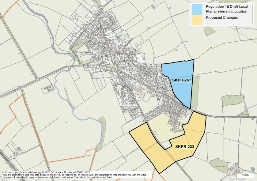
Figure 15: This map shows the village of Corby Glen and highlights two site allocations. SKPR-247 was identified as a preferred housing allocation in the Regulation 18 Draft Local Plan. SKPR-233 is proposed as a new housing allocation.
SKPR-247 – Land north of Bourne Road View responses
Indicative Unit Numbers: 144
Assumed Density: 30 Dwellings per hectare
The following development principles accompany this allocation:
- A public right of way passes through the site – this should be retained along with the existing hedgerow feature and be incorporated into the development of the site where possible.
- Pedestrian links, such as footway and cycleway connections into the centre of village from the site should be incorporated in the development proposal.
- Frontage footway to be provide on Bourne Road with existing ditch culverted.
- Sensitive landscaping screening to the north east edge of the site will be required to protect the views from the open countryside.
- Potential landscape impacts should be mitigated through high quality design and landscaping.
- This site is situated within a Limestone Mineral Safeguarding Area. Before considering a planning application for this site a Minerals Assessment will be required.
- This site is within or includes an area of Biodiversity Opportunity. Proposals on this site should incorporate the relevant principles for development within Biodiversity Opportunity Areas set out in New Policy 4: Biodiversity Opportunity and Delivering Measurable Net Gains.
- This site is within or includes a Green Infrastructure Area. Proposals on this site should incorporate the relevant principles for development within Green Infrastructure Areas set out in Policy EN3 Green Infrastructure.
Summary of Proposed Changes
No amendments to policy SKPR-247 Land north of Bourne Road, Corby Glen are proposed at this draft stage.
SKPR-233 Land fronting Bourne Road and Swinstead Road View responses
Indicative Unit Numbers: 293
Assumed Density: 30 Dwellings per hectare
The following development principles accompany this allocation:
- Footway provision required along Bourne Road and B1176 to connect to village centre.
- Sensitive landscaping screening to the south and west edges of the site will be required to protect the views from the open countryside.
- Potential landscape impacts should be mitigated through high quality design and landscaping.
- Pre-commencement archaeological investigations required.
- This site is situated within a Limestone Mineral Safeguarding Area. Before considering a planning application for this site a Minerals Assessment will be required.
- This site is within or includes an area of Biodiversity Opportunity. Proposals on this site should incorporate the relevant principles for development within Biodiversity Opportunity Areas set out in New Policy 4: Biodiversity Opportunity and Delivering Measurable Net Gains.
- This site is within or includes a Green Infrastructure Area. Proposals on this site should incorporate the relevant principles for development within Green Infrastructure Areas set out in Policy EN3 Green Infrastructure
For instructions on how to use the system and make comments, please see our help guide.