Proposed Housing and Mixed-Use Site Allocations
The Deepings View responses
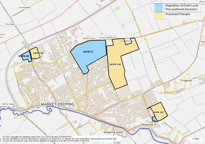
Figure 6: This map shows the town of the Deepings and highlights five site allocations. SKPR-36 and SKPR-37 were identified as preferred housing allocations in the Regulation 18 Draft Local Plan. Part of the land of allocation SKPR-307 was a proposed allocation in the Regulation 18 Draft Local Plan and includes land to east as a proposed change. SKPR-330 is proposed as a new housing allocation.
SKPR-36 (DEP1-H1): Towngate West View responses
Indicative Unit Numbers: 73
Approximate Density: 23 Dwellings per hectare – lower density based on heritage/conservation constraints and to ensure a high quality gateway development
The following development principles accompany this allocation:
- A comprehensive masterplan is required for the site.
- Highway, footway, cycleway connections shall be provided throughout site which connect the site into the wider town.
- This site represents an important gateway location, with heritage and conservation features, this should be recognised in the design and layout of development proposals and proposals should seek to enhance the Peterborough Road frontage.
- Sensitive landscaping shall be incorporated along the western edge of the site.
- To ensure the development achieves good, high quality design, a design code will be prepared for the site.
- This site is situated within a Minerals Safeguarding Area. Before considering a planning application or allocation for this site a Minerals Assessment will be required.
- This site is within or includes a Green Infrastructure Area. Proposals on this site should incorporate the relevant principles for development within Green Infrastructure Areas set out in Policy EN3 Green Infrastructure.
- The development should positively preserve and enhance the Deepings Green Walk and the designated Green Lane along Millfield Road in accordance with the Deepings Neighbourhood Plan
Summary of Proposed Changes
Outline planning permission has been granted for 80 dwellings.
Additional criterion (h) has been added to include reference to Deepings Green Walk as identified in The Deepings Neighbourhood Plan.
SKPR-37 (DEP1-H2): Linchfield Road View responses
Indicative Unit Numbers: 680
Approximate Density: 30 Dwellings per hectare
The following development principles accompany this allocation:
- A comprehensive masterplan is required for the site.
- Highway, footway, cycleway connections to be provided throughout the sites which connect the sites into the wider town and SKPR-330 Land east of Linchfield Road. The existing footpath running through the sites should be incorporated into the development.
- The development should make contributions towards public transport, education, health and community facilities and open space provision.
- The development shall accommodate specialist housing needs through the provision of retirement housing, extra care or residential care housing.
- Sensitive landscaping shall be incorporated along the eastern edges of the site.
- To ensure the development achieves good, high quality design, a design code will be prepared for the site.
- This site is situated within a Minerals Safeguarding Area. Before considering a planning application or allocation for this site a Minerals Assessment will be required.
- This site is within or includes an area of Biodiversity Opportunity. Proposals on this site should incorporate the relevant principles for development within Biodiversity Opportunity Areas set out in New Policy 4: Biodiversity Opportunity and Delivering Measurable Net Gains.
- This site is within or includes a Green Infrastructure Area. Proposals on this site should incorporate the relevant principles for development within Green Infrastructure Areas set out in Policy EN3 Green Infrastructure.
- The development should positively preserve and enhance the Deepings Green Walk in accordance with the Deepings Neighbourhood Plan
Summary of Proposed Changes
Additional criterion (j) has been added to include reference to Deepings Green Walk as identified in The Deepings Neighbourhood Plan.
Policy amended to include the requirement of Highway, footway, cycleway connections to SKPR-330 Land east of Linchfield Road.
SKPR-307 (SKPR-26) – Priory Farm Land, Deeping St James View responses
Indicative Unit Numbers: 193
Assumed Density: 35 Dwellings per hectare
The following development principles accompany this allocation:
- The development proposal should seek to preserve and enhance the rural character of the designated Green Lane (Back Lane) that runs along the Southern edge of the site in accordance with the Deepings Neighbourhood Plan.
- Landscape screening to the eastern edge of the site will be required to reduce the impact on views into the site from the open countryside.
- Development of the site should seek to positively incorporate views towards Priory Church of St James and its setting.
- This site is within or includes a Green Infrastructure Area. Proposals on this site should incorporate the relevant principles for development within Green Infrastructure Areas set out in Policy EN3 Green Infrastructure.
- This site is situated within a Minerals Safeguarding Area. Before considering a planning application or allocation for this site a Minerals Assessment will be required.
Summary of Proposed Changes
SKPR-307 includes SKPR-26, which was proposed as an allocation in the Draft Local Plan. A larger site at Priory Farm Land, Deeping St James is proposed for allocation to meet the minimum housing requirement for South Kesteven over the plan period.
Criterion relating to the designated Green Lane has been strengthened.
SKPR-55 Towngate East, Market Deeping View responses
Indicative Unit Numbers: 104
Assumed Density: 35 dwellings per hectare
The following development principles accompany this allocation:
- The site (Peterborough Road frontage) represents a gateway location, and this should be recognised in the design and layout of development proposals.
- Access from Peterborough Road. Spitfire Park, a private road, to be upgraded to an adoptable standard
- Highway, footway, cycleway connections should be provided through the site which connects the site into the wider town.
- Incorporate and retain existing trees and frontage hedgerows where possible within the design and layout of development proposals.
- The development should positively preserve and enhance the Deepings Green Walk in accordance with the Deepings Neighbourhood Plan.
- A Heritage Impact Assessment required, including consideration of the impact of the development on the setting of Towngate Farmhouse and associated outbuildings, Store at Corner Farm, and Stable and Granary Corner Farm (all Grade II listed).
- Pre-commencement archaeological interventions required.
- This site is within or includes a Green Infrastructure Opportunity Area. Proposals on this site should incorporate the relevant principles for development within Green Infrastructure Areas set out in Policy EN3 Green Infrastructure.
- This site is situated within a Minerals Safeguarding Area. Before considering a planning application or allocation for this site a Minerals Assessment will be required.
Summary of Proposed Changes
SKPR-55 Towngate East, Market Deeping is proposed to be deallocated for employment and allocated for residential use to meet the minimum housing requirement for South Kesteven over the plan period.
SKPR-330 Land east of Linchfield Road, Market Deeping View responses
Indicative Unit Numbers: 840
Assumed Density: 35 Dwellings per hectare
The following development principles accompany this allocation:
- A comprehensive masterplan is required for the site.
- To ensure the development achieves good, high quality design, a design code will be prepared for the site.
- A Transport Assessment is required.
- Highway, footway, and cycleway connections should be provided through the site which connect the site into the wider town, and SKPR-37 (DEP1-H2): Linchfield Road.
- A public right of way passes through the site – this should be retained and incorporated into the development of the site where possible.
- The development should make contributions towards public transport, education, health and community facilities and open space provision.
- Heritage Impact Assessment required, and pre-commencement investigations to be carried out due to potential for archaeological remains on the site.
- Landscape screening to the eastern edge of the site will be required to reduce the impact on views into the site from the open countryside.
- The development should positively preserve and enhance the Deepings Green Walk in accordance with the Deepings Neighbourhood Plan.
- This site is situated within a Minerals Safeguarding Area. Before considering a planning application or allocation for this site a Minerals Assessment will be required